IMAGES TAKEN NEAR TO
The Parade, LOSTWITHIEL, PL22 0DY
Introduction
This page details the photographs taken nearby to The Parade, PL22 0DY by members of the Geograph project.
The Geograph project started in 2005 with the aim of publishing, organising and preserving representative images for every square kilometre of Great Britain, Ireland and the Isle of Man.

There are currently over 7.5m images from over14,400 individuals and you can help contribute to the project by visiting https://www.geograph.org.uk
Image Map
Images are licensed for reuse under creativecommons.org/licenses/by-sa/2.0
Notes
- Clicking on the map will re-center to the selected point.
- The higher the marker number, the further away the image location is from the centre of the postcode.
Image Listing (203 Images Found)
Images are licensed for reuse under creativecommons.org/licenses/by-sa/2.0
Image
Details
Distance
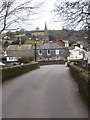
1
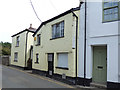
The Globe Inn, North Street, Lostwithiel
This turned out to be a good choice for a lunch stop - quiet, friendly service and excellent food. See Image for a view from the other direction; Peter Holmes describes it there as 13th century, but if that is so, then I'm very surprised that it is not listed.
Image: © Stephen Craven
Taken: 8 Aug 2018
0.01 miles
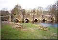
2
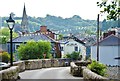
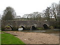
Lostwithiel: View across Respryn Bridge
The town and the prominent feature of St. Bartholomew's Church.
Image: © Mr Eugene Birchall
Taken: 1 Jul 2015
0.01 miles
3
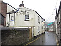
The Globe Inn, North Street
The Globe Inn is a 13th century friendly freehouse, with a reputation for excellent food, variety of real ales and the quality of its Bed and Breakfast accommodation.
Image: © Peter Holmes
Taken: 8 May 2014
0.01 miles
5
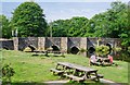
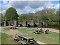
Lostwithiel: Picnic Tables near Respryn Bridge
Image: © Mr Eugene Birchall
Taken: 1 Jul 2015
0.02 miles
6
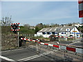
Level Crossing Lostwithiel
Level Crossing adjacent to Lostwithiel Station
Image: © David Barnes
Taken: 21 Apr 2007
0.03 miles
7
Tudor Bridge, Lostwithiel
First built by the Normans, and rebuilt in stone in the early 14C. Five pointed arches and one round one, on the right, made necessary as the river changed its course. Apparently there were also four arches to the west, now buried under North Street.
Image: © Humphrey Bolton
Taken: 7 Mar 2001
0.03 miles
8
Lostwithiel Bridge
Looking across the medieval bridge towards the town. The spire of St Bartholomew's Church Image is in the centre of the picture.
Image: © Rod Allday
Taken: 20 Feb 2011
0.03 miles
9
Lostwithiel Bridge viewed from downstream
This ancient bridge, being the lowest crossing across the River Fowey, dates from the mid C15th and is a scheduled ancient monument and Grade I listed structure. The river is tidal at this point and the tide is low at the time of the photograph.
Image: © Rod Allday
Taken: 20 Feb 2011
0.03 miles
10
Picnic area by Lostwithiel Old Bridge
15th C Grade I listed stone bridge over the river Fowey, built to replace a previous wooden bridge.
Image: © Eirian Evans
Taken: 15 May 2013
0.03 miles