IMAGES TAKEN NEAR TO
Bodmin Hill, LOSTWITHIEL, PL22 0AJ
Introduction
This page details the photographs taken nearby to Bodmin Hill, PL22 0AJ by members of the Geograph project.
The Geograph project started in 2005 with the aim of publishing, organising and preserving representative images for every square kilometre of Great Britain, Ireland and the Isle of Man.

There are currently over 7.5m images from over14,400 individuals and you can help contribute to the project by visiting https://www.geograph.org.uk
Image Map (Loading...)


Getting Data...Please wait
Leaflet Map data © OpenStreetMap
Images are licensed for reuse under creativecommons.org/licenses/by-sa/2.0
Notes
- Clicking on the map will re-center to the selected point.
- The higher the marker number, the further away the image location is from the centre of the postcode.
Image Listing (30 Images Found)
Images are licensed for reuse under creativecommons.org/licenses/by-sa/2.0
Image
Details
Distance
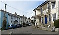
1
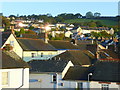
Lostwithiel roofscape - early morning
View from a hotel window - the bright autumn sun is glinting in a couple of east-facing windows.
Image: © Jonathan Billinger
Taken: 8 Oct 2008
0.14 miles
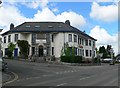
4
Lostwithiel Old Fire Station
Lostwithiel Old Fire Station, Bodmin Hill, Lostwithiel, Cornwall. Originally used as a cinema, then converted to a fire station. Since the new fire station in Pleyber Christ Way has been opened (see Image), it has been converted to a domestic dwelling.
Image: © Kevin Hale
Taken: 26 Sep 2004
0.19 miles
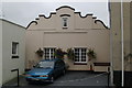
6
The Royal Talbot
Still a public house when we visited in May 2013, but by the year end it had closed and was later converted into flats.
Image: © Eirian Evans
Taken: 15 May 2013
0.20 miles
7

The Royal Talbot, Lostwithiel
This inter-war pub on the main road is now converted into flats.
Image: © Christopher Hilton
Taken: 29 Oct 2016
0.20 miles
8
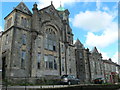
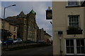
Methodist Free Church, Albert Terrace
Methodist Free Church with attached Sunday School, dated 1900. Lostwithiel United Free Methodist Church was constructed on The Bank (renamed Albert Terrace in 1846 after the visit of Queen Victoria and Albert). This chapel was rebuilt in the late 1890’s and was reopened in 1900 becoming known locally as Bank Methodist Chapel. This chapel was closed in 1987 and converted into apartments and the local Methodists then met in nearby St Saviours Church (Anglican) on Grenville Road.
Image: © Eirian Evans
Taken: 15 May 2013
0.20 miles
9
The Towerhouse
Former Wesleyan Chapel now turned into apartments.
Image: © Paul Barnett
Taken: 1 Jan 2016
0.20 miles
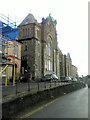
10
Lostwithiel: former Methodist Free Church
The former Methodist Free Church (and, beyond it, the former Sunday School) are now converted to residential use.
Image: © Christopher Hilton
Taken: 29 Oct 2016
0.20 miles