IMAGES TAKEN NEAR TO
IVYBRIDGE, PL21 9HP
Introduction
This page details the photographs taken nearby to PL21 9HP by members of the Geograph project.
The Geograph project started in 2005 with the aim of publishing, organising and preserving representative images for every square kilometre of Great Britain, Ireland and the Isle of Man.

There are currently over 7.5m images from over14,400 individuals and you can help contribute to the project by visiting https://www.geograph.org.uk
Image Map
Images are licensed for reuse under creativecommons.org/licenses/by-sa/2.0
Notes
- Clicking on the map will re-center to the selected point.
- The higher the marker number, the further away the image location is from the centre of the postcode.
Image Listing (13 Images Found)
Images are licensed for reuse under creativecommons.org/licenses/by-sa/2.0
Image
Details
Distance
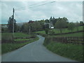
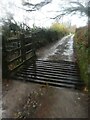
1
Cattle grid below Hanger Down
This is on Cornwood Footpath 19, following a track through Blachford Park. On the right is a small wood.
Image: © Derek Harper
Taken: 5 Jul 2013
0.16 miles
2
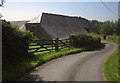
Barn at Moor
This fine slate-roofed granite barn - three farm buildings in one L-shape really - is described briefly at http://list.english-heritage.org.uk/resultsingle.aspx?uid=1309624&searchtype=mapsearch . This is on the lane from Hanger Down to Moor Cross.
Image: © Derek Harper
Taken: 5 Jul 2013
0.17 miles
3
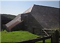
Barn at Moor
A slightly closer view of the listed barn http://list.english-heritage.org.uk/resultsingle.aspx?uid=1325394&searchtype=mapsearch shown in Image In the background across the Yealm valley is Storridge Wood.
Image: © Derek Harper
Taken: 5 Jul 2013
0.17 miles
4
Cattle grid near Hanger Down, in the rain
A day of rain and drizzle affected the photographer
Image: © David Smith
Taken: 13 Dec 2021
0.19 miles
5

On the path between Hanger Down Cottages and Uppaton
To the right just beyond the hedge a small conifer plantation was being felled because it had the disease attacking Larch trees etc.
Image: © jeff collins
Taken: 25 Jun 2014
0.19 miles
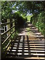
6
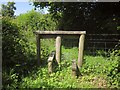
Stile, Moor
There are two of these rather odd stiles on Cornwood Footpath 5. They require you to throw your weight from one side to the other, and in this case the left hand crosspiece is loose in the ground, which makes it rather dangerous.
Image: © Derek Harper
Taken: 5 Jul 2013
0.20 miles
7
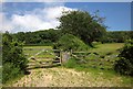
Gates below Stone Wood
From another gateway on the other side of the track carrying Cornwood Footpath 19. Stone Wood is in the background.
Image: © Derek Harper
Taken: 5 Jul 2013
0.21 miles
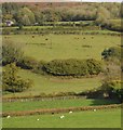
9
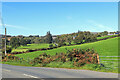
Near Houndle Farm
View towards Cornwood.
Image: © Wayland Smith
Taken: 27 Sep 2020
0.23 miles