IMAGES TAKEN NEAR TO
Ugborough, IVYBRIDGE, PL21 0PB
Introduction
This page details the photographs taken nearby to PL21 0PB by members of the Geograph project.
The Geograph project started in 2005 with the aim of publishing, organising and preserving representative images for every square kilometre of Great Britain, Ireland and the Isle of Man.

There are currently over 7.5m images from over14,400 individuals and you can help contribute to the project by visiting https://www.geograph.org.uk
Image Map
Images are licensed for reuse under creativecommons.org/licenses/by-sa/2.0
Notes
- Clicking on the map will re-center to the selected point.
- The higher the marker number, the further away the image location is from the centre of the postcode.
Image Listing (10 Images Found)
Images are licensed for reuse under creativecommons.org/licenses/by-sa/2.0
Image
Details
Distance
1
Waterman, Ugborough
The farm seen from a corner of the churchyard at Ugborough. Hidden in between are the A3121 and a disused quarry.
Image: © Derek Harper
Taken: 29 Aug 2006
0.04 miles
2
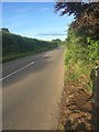
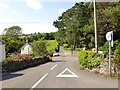
The A3121
On the outskirts of Ugborough, heading towards Plymouth.
Image: © jeff collins
Taken: 3 Jul 2020
0.16 miles
3
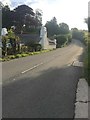
Parsonage Lodge
On the edge of Ugborough. The main road is the A3121.
Image: © jeff collins
Taken: 3 Jul 2020
0.17 miles
4
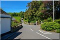
Ugborough : Parsonage Lane
Looking along the lane off the A3121.
Image: © Lewis Clarke
Taken: 8 Jun 2021
0.18 miles
6
Lane to Ugborough at Haredon Cross
Ugborough church tower occupies a commanding position at the head of the valley
Image: © Martin Bodman
Taken: 21 Jun 2018
0.23 miles
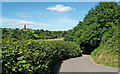
7
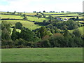
Towards Ugborough
Ugborough village on the left, with Bittaford, Butterdon Hill and Ugborough Beacon behind, and Whitehouse (farm) centre. Taken from the lane between Spriddlescombe and Oakpark Cross (same spot as Image).
Image: © Derek Harper
Taken: 29 Aug 2006
0.23 miles
8
Lane heading to Ugborough
From Haredon Cross.
Image: © jeff collins
Taken: 3 Jul 2020
0.24 miles
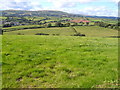
9
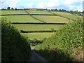
Looking over Haredon Cross
The view down the last 130 metres of the lane from Dunwell Cross to where it meets the A3121 just west of Ugborough. Beyond, a straightforward field layout on the slopes below Toby Cross.
Image: © Derek Harper
Taken: 29 Aug 2006
0.24 miles
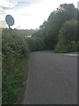
10
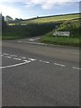
Haredon Cross
On the A3121, passing Ugborough. A slightly different view to : Image]
Image: © jeff collins
Taken: 3 Jul 2020
0.24 miles