IMAGES TAKEN NEAR TO
Ermington Road, IVYBRIDGE, PL21 0LF
Introduction
This page details the photographs taken nearby to Ermington Road, PL21 0LF by members of the Geograph project.
The Geograph project started in 2005 with the aim of publishing, organising and preserving representative images for every square kilometre of Great Britain, Ireland and the Isle of Man.

There are currently over 7.5m images from over14,400 individuals and you can help contribute to the project by visiting https://www.geograph.org.uk
Image Map
Images are licensed for reuse under creativecommons.org/licenses/by-sa/2.0
Notes
- Clicking on the map will re-center to the selected point.
- The higher the marker number, the further away the image location is from the centre of the postcode.
Image Listing (20 Images Found)
Images are licensed for reuse under creativecommons.org/licenses/by-sa/2.0
Image
Details
Distance
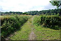
1
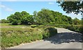
Ermington Road
The road down the Erme valley south of Ivybridge makes a bend that takes it away from the river to Newlands Cross. The Erme-Plym Trail, however, which has followed the road for about 200 metres, continues straight on (to the right here) along Ugborough footpath 30.
Image: © Derek Harper
Taken: 24 May 2017
0.02 miles
2
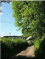
Erme-Plym Trail at Yeo Farm
Buildings at Yeo Farm beside the trail following Ugborough Footpath 30 along a farm track.
Image: © Derek Harper
Taken: 24 May 2017
0.02 miles
3
Erme-Plym Trail at Yeo Farm
The tarmac drive is about to swing right to the farmhouse. The trail continues straight ahead along a footpath to Lower Keaton.
Image: © Derek Harper
Taken: 23 Jul 2009
0.06 miles
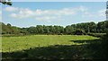
4
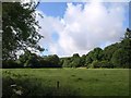
Field beside the Erme
Taken from the Erme-Plym Trail as it passes Riverside. The right-hand side of this field on the flood plain borders the River Erme.
Image: © Derek Harper
Taken: 23 Jul 2009
0.07 miles
5
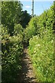
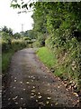
Erme-Plym Trail by Ermington Road
The trail follows this path that serves as the pavement for Ermington Road but is far more pleasant, albeit somewhat overgrown with grasses.
Image: © Derek Harper
Taken: 24 May 2017
0.09 miles
6
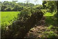
Erme-Plym trail near Yeo Farm
The trail follows Ugborough footpath 30 on the left past the ivy-crowned barn shown in Image The background trees on the right are in Lissonpiece Wood, climbing steeply from the River Erme.
Image: © Derek Harper
Taken: 24 May 2017
0.10 miles
7
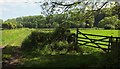
Track near Yeo Farm
A field access track (not a right of way) to an otherwise inaccessible riverside field, taken by the gate shown in Image
Image: © Derek Harper
Taken: 24 May 2017
0.10 miles
8
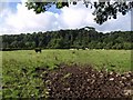
Meadow by the Erme
Cattle graze in a meadow on the Erme flood plain. The river is a further field away; behind it, Lissonpiece Wood rises up a river cliff. Seen from the Erme-Plym Trail.
Image: © Derek Harper
Taken: 23 Jul 2009
0.12 miles
9
Erme Plym Trail
This part of the trail is just after Yeolands,heading towards Lower Keaton.
Image: © jeff collins
Taken: 27 Jun 2009
0.12 miles
10
Cattle near Yeo Farm
A more distant view from the gate on Ugborough footpath 30 shown in Image, of the herd shown in Image On the right is the derelict ivy-covered barn also shown in Image
Image: © Derek Harper
Taken: 24 May 2017
0.13 miles