IMAGES TAKEN NEAR TO
Marshals Field, IVYBRIDGE, PL21 0FQ
Introduction
This page details the photographs taken nearby to Marshals Field, PL21 0FQ by members of the Geograph project.
The Geograph project started in 2005 with the aim of publishing, organising and preserving representative images for every square kilometre of Great Britain, Ireland and the Isle of Man.

There are currently over 7.5m images from over14,400 individuals and you can help contribute to the project by visiting https://www.geograph.org.uk
Image Map
Images are licensed for reuse under creativecommons.org/licenses/by-sa/2.0
Notes
- Clicking on the map will re-center to the selected point.
- The higher the marker number, the further away the image location is from the centre of the postcode.
Image Listing (49 Images Found)
Images are licensed for reuse under creativecommons.org/licenses/by-sa/2.0
Image
Details
Distance
1
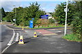
Entrance to Stowford school and Community College Ivybridge
Image: © jeff collins
Taken: 18 Sep 2013
0.08 miles
2
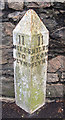
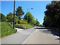
Old Milepost by the B3213, Exeter Road, Ivybridge
Cast iron post by the B3213 (was A38), in parish of IVYBRIDGE (SOUTH HAMS District), Exeter Road, Northeast of Torr Hill House, in pavement, against wall, on Southwest side of road. Plymouth spear iron casting, erected by the Plymouth, Eastern turnpike trust in the 19th century.
Inscription reads:-
: 11 / MILES / TO / PLYM⁰ : : 11 / MILES / FROM / PLYM⁰ :
Grade II listed.
List Entry Number: 1107426 https://historicengland.org.uk/listing/the-list/list-entry/1107426
Milestone Society National ID: DV_PLEX11
Image: © T Jenkinson
Taken: 19 Jan 2007
0.10 miles
3
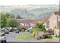
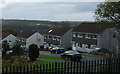
Modern Housing in Ivybridge
Once a village, Ivybridge is now a town and dormitory suburb of Plymouth. This photograph shows typical modern housing on the eastern side of Ivybridge.
Image: © Tony Atkin
Taken: 6 Sep 2005
0.11 miles
9
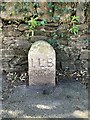
Old Boundary Marker on the B3213 Exeter Road in Ivybridge
Municipal Boundary Marker against a stone wall on the south side of the B3213 Exeter Road, formerly the A38, 30 metres east of Springwood Close. Ivybridge parish. ILB is Ivybridge Local Board set up to tackle the problem of sewage disposal within four parishes.
Milestone Society National ID: DV_PLEX011apb
Image: © J Browne
Taken: 31 Mar 2022
0.15 miles
10
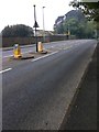
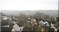
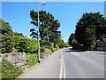
Exeter Rd
The B3213 heading towards Ivybridge town centre.
Image: © jeff collins
Taken: 25 Apr 2020
0.18 miles