IMAGES TAKEN NEAR TO
Tavistock Road, YELVERTON, PL20 6ED
Introduction
This page details the photographs taken nearby to Tavistock Road, PL20 6ED by members of the Geograph project.
The Geograph project started in 2005 with the aim of publishing, organising and preserving representative images for every square kilometre of Great Britain, Ireland and the Isle of Man.

There are currently over 7.5m images from over14,400 individuals and you can help contribute to the project by visiting https://www.geograph.org.uk
Image Map
Images are licensed for reuse under creativecommons.org/licenses/by-sa/2.0
Notes
- Clicking on the map will re-center to the selected point.
- The higher the marker number, the further away the image location is from the centre of the postcode.
Image Listing (14 Images Found)
Images are licensed for reuse under creativecommons.org/licenses/by-sa/2.0
Image
Details
Distance
3
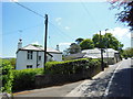
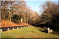
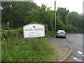
Old Toll House by Tavistock Road, Horrabridge
Toll House by the A386, in the parish of Horrabridge (West Devon District), Toll House, Tavistock Road, PL20 6EB.
Surveyed
Milestone Society National ID: DV.HOR01
Image: © Alan Rosevear
Taken: Unknown
0.07 miles
7
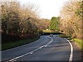
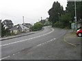
The Road to Tavistock
It's downhill all the way from Yelverton to Tavistock.
Image: © Tony Atkin
Taken: 4 Dec 2005
0.10 miles
8
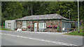
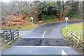
The Road to the Downs
This minor road leaves the A386 at Horrabridge and zigzags its way up the hillside onto the downland above the village.
Image: © Tony Atkin
Taken: 7 Dec 2008
0.12 miles
10
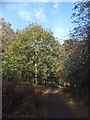
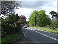
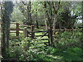
Drake's Trail on the edge of Horrabridge
This is part of NCN27 (Devon Coast to Coast). The slope through woodland leads down to the former Horrabridge railway station, from where the trail follows the track of the dismantled railway line
Image: © David Smith
Taken: 30 Oct 2012
0.13 miles