IMAGES TAKEN NEAR TO
Sowton Road, YELVERTON, PL20 6DB
Introduction
This page details the photographs taken nearby to Sowton Road, PL20 6DB by members of the Geograph project.
The Geograph project started in 2005 with the aim of publishing, organising and preserving representative images for every square kilometre of Great Britain, Ireland and the Isle of Man.

There are currently over 7.5m images from over14,400 individuals and you can help contribute to the project by visiting https://www.geograph.org.uk
Image Map (Loading...)


Getting Data...Please wait
Leaflet Map data © OpenStreetMap
Images are licensed for reuse under creativecommons.org/licenses/by-sa/2.0
Notes
- Clicking on the map will re-center to the selected point.
- The higher the marker number, the further away the image location is from the centre of the postcode.
Image Listing (5 Images Found)
Images are licensed for reuse under creativecommons.org/licenses/by-sa/2.0
Image
Details
Distance
1
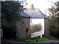
Uphill near Roborough Down
This ancient stone house is the shape of a three-sided square - the fourth side being the garden fence. This gives the front a very sheltered outlook. It is situated on the side of the lane dipping steeply down towards a junction and below that a stream.
Image: © Sarah Smith
Taken: 13 Dec 2009
0.09 miles
2
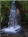
Miniature waterfall
Surface water from the fields comes racing off in torrents into a rivulet by the side of the lane. The sound of rushing water is everywhere as one walks along under the trees.
Image: © Sarah Smith
Taken: 13 Dec 2009
0.13 miles
3
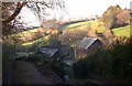
Coombe Farm
A typical farmstead located in a valley to the west of Roborough Down
Image: © Tony Atkin
Taken: 11 Dec 2005
0.18 miles
4
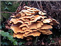
Chicken of the woods?
This fungus was growing out of the side of a tree in the undergrowth of a hedge bank. The surroundings were damp and shady and the lane was lined with trees. I would be pleased to receive confirmation that this is Laetiporus sulphureus (chicken of the woods).
Thank you Ceridwen - this is Chicken of the Woods fungus.
Image: © Sarah Smith
Taken: 13 Dec 2009
0.19 miles
5
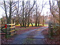
Cattle grid - Roborough Down
Roborough Down being a thin slice of moorland and once part of Dartmoor is full of livestock and ponies which have to be kept off the busy A386 Plymouth road and the neighbouring lanes. In order to do this, all the vehicle access routes are crossed by cattlegrids at point of entry on to the Down.
Image: © Sarah Smith
Taken: 13 Dec 2009
0.21 miles