IMAGES TAKEN NEAR TO
TAVISTOCK, PL19 9LD
Introduction
This page details the photographs taken nearby to PL19 9LD by members of the Geograph project.
The Geograph project started in 2005 with the aim of publishing, organising and preserving representative images for every square kilometre of Great Britain, Ireland and the Isle of Man.

There are currently over 7.5m images from over14,400 individuals and you can help contribute to the project by visiting https://www.geograph.org.uk
Image Map
Images are licensed for reuse under creativecommons.org/licenses/by-sa/2.0
Notes
- Clicking on the map will re-center to the selected point.
- The higher the marker number, the further away the image location is from the centre of the postcode.
Image Listing (24 Images Found)
Images are licensed for reuse under creativecommons.org/licenses/by-sa/2.0
Image
Details
Distance
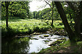
1
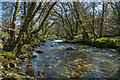
River Walkham
Upstream from Double Waters.
Image: © Guy Wareham
Taken: 23 Apr 2016
0.09 miles
2
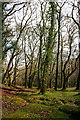
Valley-Bottom Woodland
By the side of the River Walkham at Double Waters.
Image: © Tony Atkin
Taken: 13 Apr 2008
0.11 miles
3
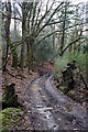
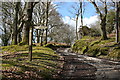
Woodland Road
This rough roadway takes the West Devon Way down to the footbridge at Double Waters.
Image: © Tony Atkin
Taken: 13 Apr 2008
0.12 miles
4
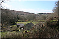
Whitchurch: near Buckator
Looking south west in the Walkham valley
Image: © Martin Bodman
Taken: 1 Apr 2009
0.12 miles
5
Bridleway Junction
Just north of Double Waters, the path ahead will take you up the hill towards Tavistock and the path off to the right, along the side of the River Walkham to Grenofen Bridge.
Image: © Tony Atkin
Taken: 13 Apr 2008
0.13 miles
6
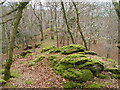
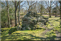
Wooded ridge between Rivers Tavy and Walkham
Moss-covered boulders beside the West Devon Way just before it drops down to Double Waters, where the Walkham (below left) joins the Tavy (below right). Looking south-west.
Image: © Derek Harper
Taken: 30 Jan 2005
0.15 miles
7
Whitchurch: rock above the Tavy
By the track from West Down to Buckator and to Double Waters, where the Tavy meets the Walkham
Image: © Martin Bodman
Taken: 10 Mar 2010
0.15 miles
8
Whitchurch: Lower Walkham Valley 3
The river Walkham
Image: © Martin Bodman
Taken: 11 Jun 2009
0.16 miles
9
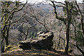
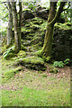
The Rock
An isolated rock close to the bridleway from West Down to Tavy Cottage.
Image: © Guy Wareham
Taken: 23 Apr 2016
0.16 miles
10
Whitchurch: Goat Rock
Not named on maps, Goat Rock was so called by a visitor, Mrs Bray, in 1836. By the confluence of the rivers Tavy and Walkham, known as Double Waters. Looking north-north-east. [Source: Paul Rendell. Exploring the Lower Walkham Valley. Forest Publishing, 1996, 30]
Image: © Martin Bodman
Taken: 28 Jun 2007
0.18 miles