IMAGES TAKEN NEAR TO
Buddle Close, TAVISTOCK, PL19 0EG
Introduction
This page details the photographs taken nearby to Buddle Close, PL19 0EG by members of the Geograph project.
The Geograph project started in 2005 with the aim of publishing, organising and preserving representative images for every square kilometre of Great Britain, Ireland and the Isle of Man.

There are currently over 7.5m images from over14,400 individuals and you can help contribute to the project by visiting https://www.geograph.org.uk
Image Map
Images are licensed for reuse under creativecommons.org/licenses/by-sa/2.0
Notes
- Clicking on the map will re-center to the selected point.
- The higher the marker number, the further away the image location is from the centre of the postcode.
Image Listing (13 Images Found)
Images are licensed for reuse under creativecommons.org/licenses/by-sa/2.0
Image
Details
Distance
1
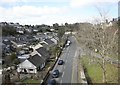
View from above
The view from the former railway viaduct looking away from Tavistock. The road on the right led into the former station goods yard and upside platforms.
Image: © roger geach
Taken: 4 Apr 2010
0.17 miles
2
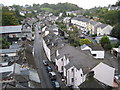
Tavistock roofscape (1)
Viewed from Tavistock Viaduct, the photograph shows Bannawell Street on the left, Lakeside on the right, and houses on Drake Road on the upper right.
Image: © Nigel Cox
Taken: 6 Oct 2008
0.18 miles
3
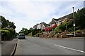
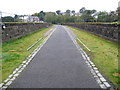
Redmoor Close, Tavistock
A modern suburban development on the northern edge of Tavistock. It's a short walk from the town centre to here but very steep uphill.
Image: © Tony Atkin
Taken: 4 Jun 2006
0.20 miles
4
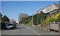
Redmoor Close, Tavistock
Taken a little further up the road shown in Image
Image: © Derek Harper
Taken: 14 Apr 2015
0.22 miles
5
Former railway viaduct over Drake Road
This now carries NCN27 as part of the Devon Coast to Coast route
Image: © David Smith
Taken: 26 Mar 2013
0.23 miles
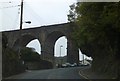
6
Tavistock railway viaduct
The viaduct was opened in 1890 on the Plymouth Devonport and South Western Junction Railway's double track line from Plymouth to Lydford. The tracks were lifted after closure in 1968 and the trackbed now forms a section of the National Cycle Network's Route 27, the Devon Coast to Coast route.
(From a purely Geograph point of view the 248000 Easting gridline crosses the viaduct around its halfway point so this view is looking into Image too.)
Image: © Nigel Cox
Taken: 6 Oct 2008
0.24 miles
7
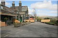
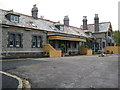
LSWR former Tavistock North station frontage
Tavistock North shut from May 1968 when the line from Bere Alston to Okehampton was closed. This was on the Plymouth to Exeter railway line and Tavistock North station was sold into private ownership as were most of the stations along this route.
Image: © roger geach
Taken: 4 Apr 2010
0.24 miles
8
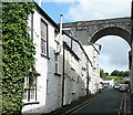
Taylor Square
The viaduct of the former LSWR route from Plymouth via Okehampton to Exeter and on to London (Waterloo) crosses high above the town. These old houses are in Taylor Square. The viaduct is now a permissive path.
Image: © Graham Horn
Taken: 31 May 2011
0.24 miles
9
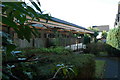
Tavistock: Former Tavistock North railway station
The station was opened in 1890 on the Plymouth Devonport and South Western Junction Railway's line from Plymouth to Lydford where it joined with the London & South Western Railway's line from London. The L&SWR gained running rights on the line to enable them to run trains directly from London to Plymouth in competition with the Great Western Railway.
The station was called Tavistock North to avoid it being confused with the separate Great Western Railway station which was named Tavistock South.
Although the line was closed in 1968, the station, which is constructed of Dartmoor granite, survived, eventually being accorded Grade II listed building status in 1999. In 2007 it was converted into three exclusive self catering accommodation apartments, the website for which is here http://www.oldtavistockrailwaystation.co.uk/index.html
Image: © Nigel Cox
Taken: 6 Oct 2008
0.25 miles
10
Tavistock North Railway Station
Tavistock North Railway Station was completed on 19th July 1889 and was opened to passenger traffic on 2nd June 1890. It served the Plymouth, Devonport & South Western Junction Railway. The Beeching Report took its toll and the last train to use this station was on 6th May 1968. During May 1999 the building became Grade II listed by English Heritage. During May 2008 the building was renovated and remodelled into three holiday houses. More details http://www.oldtavistockrailwaystation.co.uk/history-tavistockrailway/ and http://en.wikipedia.org/wiki/Tavistock_North_railway_station
Image: © Andrew Bodman
Taken: 11 Oct 2014
0.25 miles