IMAGES TAKEN NEAR TO
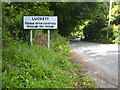
Luckett, CALLINGTON, PL17 8LF
Introduction
This page details the photographs taken nearby to PL17 8LF by members of the Geograph project.
The Geograph project started in 2005 with the aim of publishing, organising and preserving representative images for every square kilometre of Great Britain, Ireland and the Isle of Man.

There are currently over 7.5m images from over14,400 individuals and you can help contribute to the project by visiting https://www.geograph.org.uk
Image Map
Images are licensed for reuse under creativecommons.org/licenses/by-sa/2.0
Notes
- Clicking on the map will re-center to the selected point.
- The higher the marker number, the further away the image location is from the centre of the postcode.
Image Listing (10 Images Found)
Images are licensed for reuse under creativecommons.org/licenses/by-sa/2.0
Image
Details
Distance
1
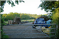
Wood piles at Luckett
Wood piles at Luckett, south east Cornwall.
Image: © Kevin Hale
Taken: 1 Jun 2006
0.08 miles
2
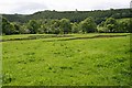
The Tamar Flood Plain near Luckett
The dark patches on the field are areas of juncus grasses occupying saturated ground.
Image: © Tony Atkin
Taken: 19 May 2007
0.17 miles
3
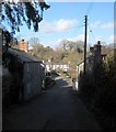
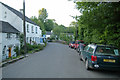
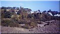
Luckett
The village street, with Luckett Bridge http://list.historicengland.org.uk/resultsingle.aspx?uid=1220500&searchtype=mapsearch visible just before the row of cottages facing the camera. The whole village forms a conservation area, more than half of which is occupied by the former New Consols Mine, its workings and buildings associated with it.
Image: © Derek Harper
Taken: 4 Mar 2015
0.17 miles
4
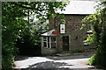
The southern approach to Luckett
In the woodland to the left of the photo there are extensive remains of the mining works at New Consols (Wheal Martha) Mine.
Image: © Rod Allday
Taken: 22 May 2011
0.18 miles
5
Luckett village, Cornwall
Luckett village, Cornwall
Image: © Kevin Hale
Taken: 1 Jun 2006
0.18 miles
6
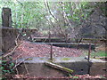
Machine bases in the woods south of Luckett
I believe that these are associated with the modern mill at Wheal Martha, dating from the 1940s. There are extensive overgrown industrial remains in the woods here, owned by the Duchy of Cornwall but with permissive public access.
Image: © Rod Allday
Taken: 22 May 2011
0.21 miles
7
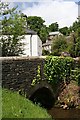
Luckett
From this bridge, Luckett village follows a steep road up the hillside. Luckett was a 19th century mining village.
Image: © Tony Atkin
Taken: 19 May 2007
0.21 miles
9
New Consols Mine in 1984
https://historicengland.org.uk/listing/the-list/list-entry/1409595?section=official-listing
Image: © Sandy Gerrard
Taken: Unknown
0.23 miles
10
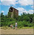
Wheal Martha or New Great Consols, Luckett
One of the engine houses on this mine, taken in 1977. This was the 28 inch crusher. The mine was noted for its complicated ores, making separation difficult. These included copper, arsenic, silver, wolfram, tin and pyrite. For many years the main pumping engine remained in its house, rusting away. These days the excessive ivy growth has more or less completely enveloped this house.
Image: © Richard Bird
Taken: 12 Aug 1977
0.23 miles