IMAGES TAKEN NEAR TO
Harrowbarrow, CALLINGTON, PL17 8JQ
Introduction
This page details the photographs taken nearby to PL17 8JQ by members of the Geograph project.
The Geograph project started in 2005 with the aim of publishing, organising and preserving representative images for every square kilometre of Great Britain, Ireland and the Isle of Man.

There are currently over 7.5m images from over14,400 individuals and you can help contribute to the project by visiting https://www.geograph.org.uk
Image Map
Images are licensed for reuse under creativecommons.org/licenses/by-sa/2.0
Notes
- Clicking on the map will re-center to the selected point.
- The higher the marker number, the further away the image location is from the centre of the postcode.
Image Listing (7 Images Found)
Images are licensed for reuse under creativecommons.org/licenses/by-sa/2.0
Image
Details
Distance
1
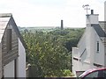
Mine chimney in the trees
Many of the old mine workings in this area are now covered in woodland. The houses in the foreground are part of a loose "ribbon development" along the road between Rising Sun and Gunnislake.
Image: © Tony Atkin
Taken: 7 Aug 2005
0.01 miles
2
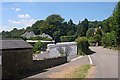
Ribbon Housing
On the minor road between Harrowbarrow and St Anne's Chapel the housing never really stops. It is a mixture of old mining cottages and more recent houses.
Image: © Tony Atkin
Taken: 7 Aug 2005
0.09 miles
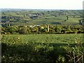
3
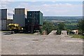
Containers on the Hillside
Part of some old mine workings is being used to store containers. This is on the lower slopes of Hingston Down and high enough above the land to the south to afford a quite a view over it.
Image: © Tony Atkin
Taken: 7 Aug 2005
0.17 miles
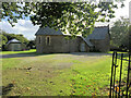
6
Chimneys, Prince of Wales Mine
From the A390 opposite the lay-by from which Image] was taken. The copper mine operated between 1865 and 1914. In the distance is St Dominick.
Image: © Derek Harper
Taken: 14 May 2014
0.19 miles
7
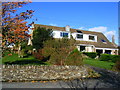
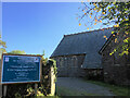
Shalam and Greenleas, Rising Sun
Note the tin-mine stack from the long-abandoned Prince of Wales mine in the background. These mine buildings have recently been upgraded by Cornwall County Council.
Image: © Simon MacLennan
Taken: 6 Nov 2008
0.22 miles