IMAGES TAKEN NEAR TO
Maders, CALLINGTON, PL17 7LL
Introduction
This page details the photographs taken nearby to PL17 7LL by members of the Geograph project.
The Geograph project started in 2005 with the aim of publishing, organising and preserving representative images for every square kilometre of Great Britain, Ireland and the Isle of Man.

There are currently over 7.5m images from over14,400 individuals and you can help contribute to the project by visiting https://www.geograph.org.uk
Image Map
Images are licensed for reuse under creativecommons.org/licenses/by-sa/2.0
Notes
- Clicking on the map will re-center to the selected point.
- The higher the marker number, the further away the image location is from the centre of the postcode.
Image Listing (11 Images Found)
Images are licensed for reuse under creativecommons.org/licenses/by-sa/2.0
Image
Details
Distance
1
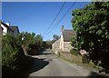
Maders
A hamlet on quite a busy road between Callington / Kelly Bray, and Golberdon / South Hill. On the right is the listed Maders Cottage http://list.english-heritage.org.uk/resultsingle.aspx?uid=1140782&searchtype=mapsearch .
Image: © Derek Harper
Taken: 14 May 2014
0.01 miles
2
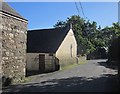
Maders
A reverse view of Image The gable on the left belongs to the listed C17 Maders Cottage http://list.english-heritage.org.uk/resultsingle.aspx?uid=1140782&searchtype=mapsearch - listed as Meaders Cottage, which I think must be wrong.
Image: © Derek Harper
Taken: 14 May 2014
0.01 miles
3
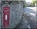
Postbox, Maders
Victorian postbox number PL17 518, close to the point at which Image] was taken.
Image: © Derek Harper
Taken: 14 May 2014
0.02 miles
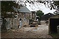
4
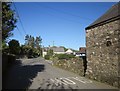
Maders
A little further along the village street shown in Image Down the road and at right angles to it is the listed Maders farmhouse http://list.english-heritage.org.uk/resultsingle.aspx?uid=1140781&searchtype=mapsearch .
Image: © Derek Harper
Taken: 14 May 2014
0.04 miles
5
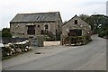
Converted Farm Buildings
This is in the hamlet of Maders. According to the wooden sign on the wall, these are The Granary and The Barn, presumably modern names which reflect their original use.
Image: © Tony Atkin
Taken: 14 Oct 2006
0.05 miles
7
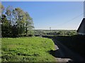
Track near Maders
From the road shown in Image The track leads to the farm at Lower Woodland.
Image: © Derek Harper
Taken: 14 May 2014
0.17 miles
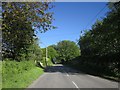
8
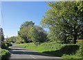
South Hill Road east of Maders
Image: © Derek Harper
Taken: 14 May 2014
0.18 miles
9
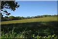
Field near Maders
A grass field beside the lane east of the hamlet.
Image: © Derek Harper
Taken: 14 May 2014
0.19 miles
10
South Hill Road east of Maders
Heading for Callington. Image] was taken from here looking to the left.
Image: © Derek Harper
Taken: 14 May 2014
0.22 miles