IMAGES TAKEN NEAR TO
LAUNCESTON, PL15 9QS
Introduction
This page details the photographs taken nearby to PL15 9QS by members of the Geograph project.
The Geograph project started in 2005 with the aim of publishing, organising and preserving representative images for every square kilometre of Great Britain, Ireland and the Isle of Man.

There are currently over 7.5m images from over14,400 individuals and you can help contribute to the project by visiting https://www.geograph.org.uk
Image Map (Loading...)


Getting Data...Please wait
Leaflet Map data © OpenStreetMap
Images are licensed for reuse under creativecommons.org/licenses/by-sa/2.0
Notes
- Clicking on the map will re-center to the selected point.
- The higher the marker number, the further away the image location is from the centre of the postcode.
Image Listing (5 Images Found)
Images are licensed for reuse under creativecommons.org/licenses/by-sa/2.0
Image
Details
Distance
1
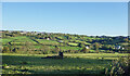
River Kensey Valley
The River Kensey flows through Launceston and joins the Tamar a short way east of here.
Image: © Des Blenkinsopp
Taken: 26 May 2021
0.07 miles
2
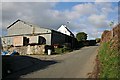
Farm Buildings at Goodmansleigh
Corrugated iron seems to be a popular building material for farm sheds around here.
Image: © Tony Atkin
Taken: 3 Feb 2007
0.08 miles
3
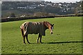
Horse near Goodmansleigh
An increasingly common use for agricultural land on the urban fringe is for pasturing horses. In the background of this photo, across the valley, are the buildings of Launceston.
Image: © Tony Atkin
Taken: 3 Feb 2007
0.14 miles
5
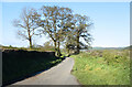
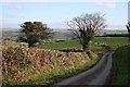
Ridgegrove Lane
A narrow country road which is also used by the Tamar Valley Discovery Trail https://www.ldwa.org.uk/ldp/members/show_path.php?path_name=Tamar+Valley+Discovery+Trail and the Two Castles Trail
https://visitdartmoor.co.uk/get-active/the-best-dartmoor-walks/two-castles-trail which both start/end at Launceston.
Image: © Des Blenkinsopp
Taken: 26 May 2021
0.25 miles