IMAGES TAKEN NEAR TO
LAUNCESTON, PL15 8HT
Introduction
This page details the photographs taken nearby to PL15 8HT by members of the Geograph project.
The Geograph project started in 2005 with the aim of publishing, organising and preserving representative images for every square kilometre of Great Britain, Ireland and the Isle of Man.

There are currently over 7.5m images from over14,400 individuals and you can help contribute to the project by visiting https://www.geograph.org.uk
Image Map
Images are licensed for reuse under creativecommons.org/licenses/by-sa/2.0
Notes
- Clicking on the map will re-center to the selected point.
- The higher the marker number, the further away the image location is from the centre of the postcode.
Image Listing (51 Images Found)
Images are licensed for reuse under creativecommons.org/licenses/by-sa/2.0
Image
Details
Distance
1
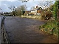
River Kensey
The swollen river seen from Riverside just west of St Thomas Road, with the upstream tip of an island on the right, and Image just keeping above the water level.
Image: © Derek Harper
Taken: 23 Nov 2009
0.01 miles
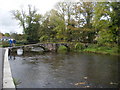
2
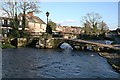
Prior's Bridge and the River Kensey
An ancient bridge over the river in Launceston.
Image: © Tony Atkin
Taken: 25 Jan 2007
0.02 miles
3
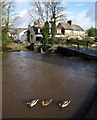
Prior's Bridge, Launceston
These mallards are happy that the Kensey is high and there is more river to swim in. Compare the level with Image, where the white mark on the central support is a couple of feet above the water. http://www.imagesofengland.org.uk/details/default.aspx?id=370137 (but see Image)
Image: © Derek Harper
Taken: 23 Nov 2009
0.02 miles
4
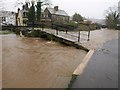
Prior's Bridge, Launceston
The level of the water is more clearly shown without sunshine - compare Image, taken nearly an hour and a half later. The height in relation to the right-hand arches can be compared with Image
There seems to be confusion about the name of the bridge. The most detailed OS map has "St Thomas Bridge", and the listed building description states "West Bridge RIVERSIDE. Also known as: St Thomas Bridge" http://www.imagesofengland.org.uk/details/default.aspx?id=370137 . But this would surely confuse with http://www.imagesofengland.org.uk/Details/Default.aspx?id=370111&mode=adv , where the nearby road bridge is also called "St Thomas's Bridge". http://www.historic-cornwall.org.uk/csus/towns/launceston/csus_launceston_report_2005R051.pdf gives "Prior's Bridge".
Image: © Derek Harper
Taken: 23 Nov 2009
0.02 miles
5
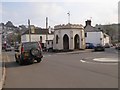
Newport Round House, built in 1829
Described in http://www.launcestonthen.co.uk/newportroundhouse.html
Image: © David Smith
Taken: 15 Apr 2016
0.03 miles
6
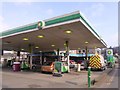
BP filling station in Newport, Launceston
Image: © David Smith
Taken: 15 Apr 2016
0.04 miles
7

The A388 crossing the River Kensey in Launceston
Image: © Roy Hughes
Taken: 31 Aug 2022
0.04 miles
9
LSWR North Cornwall railway
Once the Railway Station on the Okehampton to Padstow Line along with the GWR railway that terminated from Plymouth via Lydford. Now it's the Launceston Steam Railway's yard with a narrow gauge railway where once full size trains ran.
Image: © roger geach
Taken: 18 May 2010
0.05 miles
10
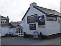
The White Horse Inn and its advertising
The lower board advertises that this is "Lanson's best Sunday carvery" using the traditional pronunciation of the town's name
Image: © David Smith
Taken: 15 Apr 2016
0.06 miles