IMAGES TAKEN NEAR TO
Upton Cross, LISKEARD, PL14 5AZ
Introduction
This page details the photographs taken nearby to PL14 5AZ by members of the Geograph project.
The Geograph project started in 2005 with the aim of publishing, organising and preserving representative images for every square kilometre of Great Britain, Ireland and the Isle of Man.

There are currently over 7.5m images from over14,400 individuals and you can help contribute to the project by visiting https://www.geograph.org.uk
Image Map
Images are licensed for reuse under creativecommons.org/licenses/by-sa/2.0
Notes
- Clicking on the map will re-center to the selected point.
- The higher the marker number, the further away the image location is from the centre of the postcode.
Image Listing (24 Images Found)
Images are licensed for reuse under creativecommons.org/licenses/by-sa/2.0
Image
Details
Distance
1
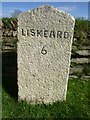
Old Milestone by the B3254, north of Upton Cross
Carved stone post by the B3254, in parish of LINKINHORNE (CARADON District), Upton, on minor crossroads in front of Cornish hedge, on East side of road. Gravestone, erected by the Local Highways Board in the 19th century.
Inscription reads:-
LISKEARD
6
Grade II listed.
List Entry Number: 1140529 https://historicengland.org.uk/listing/the-list/list-entry/1140529
Milestone Society National ID: CW_LKLA06.
Image: © Rosy Hanns
Taken: 25 Mar 2019
0.02 miles
2
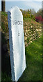
Old Milestone by the B3254, north of Upton Cross
Carved stone post by the B3254, in parish of LINKINHORNE (CARADON District), Upton, on crossroads in front of Cornish hedge, on East side of road. Gravestone, erected by the Local Highways Board in the 19th century.
Inscription reads:-
LISKEARD
6
Grade II Listed. List Entry Number: 1140529
https://historicengland.org.uk/listing/the-list/list-entry/1140529
Milestone Society National ID: CW_LKLA06.
Image: © Ian Thompson
Taken: 1 May 2001
0.02 miles
3
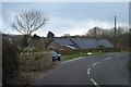
Road junction in Upton
A minor road leads to Rilla Mill
Image: © David Smith
Taken: 20 Mar 2013
0.03 miles
4
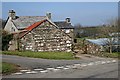
Little Upton in the hamlet of Upton
The house shown in the other photograph in this grid square is now undergoing a refit, with a number of contractors vehicles on site. This small hamlet is just a stone's throw from the village of Upton Cross, the other houses seem to be fairly modern with the exception of Upton Manor and Upton Farm. The proliferation of hamlets in Cornwall is a result of a historical preference for small groups of dwellings rather than expanding villages, and Cornwall's old local council policy of establishing 'Rural Gaps'.
Image: © Eric Foster
Taken: 14 Apr 2012
0.03 miles
5
Little Upton
Little Upton is a farmhouse and farmyard which is no longer used as such but is now just private housing.
Image: © Tony Atkin
Taken: 24 Mar 2007
0.04 miles
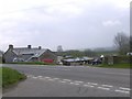
6
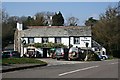
The Caradon Inn
Another photo (see Image) of the pub beside the B3254. It is on the fringe of the designated area of the Cornwall and West Devon Mining Landscape.
Image: © Derek Harper
Taken: 20 Apr 2015
0.07 miles
7
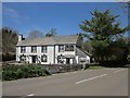
The Caradon Inn
I suppose that if you have to look for a picture postcard country pub then this might be a candidate, although it could be mistaken for a chelsea tractor garage!
Image: © Tony Atkin
Taken: 24 Mar 2007
0.08 miles
8
Lane to Upton Hall
Leaving the B3254, and curving round to the farm on the right. The farmhouse is described at http://list.historicengland.org.uk/resultsingle.aspx?uid=1140495&searchtype=mapsearch .
Image: © Derek Harper
Taken: 20 Apr 2015
0.10 miles
9
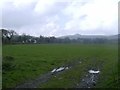
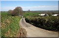
Farmland near Upton Cross
Grazing land near the village of Upton Cross, in the far distance is Sharptor, and the outline of Bodmin Moor.
Image: © Eric Foster
Taken: 14 Apr 2012
0.15 miles
10
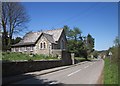
Sunday School, Upton Cross
The building dates from 1887, "constructed from the same stone as the school
and church with a similar pitched slate roof and lancet widows" http://www.historic-cornwall.org.uk/cisi/upton_cross/CISI_Upton_Cross_report.pdf - I think they mean windows. It is now used as the CrossLink Centre. http://www.achurchnearyou.com/upton-cross-st-paul/ .
Image: © Derek Harper
Taken: 20 Apr 2015
0.15 miles