IMAGES TAKEN NEAR TO
Pras Gwartha, LISKEARD, PL14 4FQ
Introduction
This page details the photographs taken nearby to Pras Gwartha, PL14 4FQ by members of the Geograph project.
The Geograph project started in 2005 with the aim of publishing, organising and preserving representative images for every square kilometre of Great Britain, Ireland and the Isle of Man.

There are currently over 7.5m images from over14,400 individuals and you can help contribute to the project by visiting https://www.geograph.org.uk
Image Map
Images are licensed for reuse under creativecommons.org/licenses/by-sa/2.0
Notes
- Clicking on the map will re-center to the selected point.
- The higher the marker number, the further away the image location is from the centre of the postcode.
Image Listing (11 Images Found)
Images are licensed for reuse under creativecommons.org/licenses/by-sa/2.0
Image
Details
Distance

2
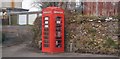
Duloe Book Store
An interesting use of an old phone box.
Image: © N Chadwick
Taken: 31 Mar 2018
0.06 miles
3
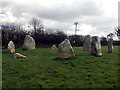
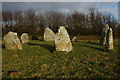
Duloe Stone Circle
Nine (Ten?) stones, all of solid quartz!
Image: © Alan Simkins
Taken: 7 Mar 2004
0.07 miles
4

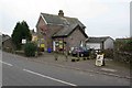
Plough House Inn Duloe
This inn is shut at the moment and is to let. Like many village pubs this has closed and awaits its fate.
Image: © roger geach
Taken: 25 Sep 2010
0.09 miles
5
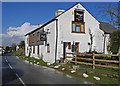
Post Office and Shop
This village still has its Post Office and shop . Many larger villages have lost them .
Image: © roger geach
Taken: 29 Nov 2008
0.10 miles
7

Duloe Village
Looking towards Dobwalls this is the Village at Duloe. The road to the left is a newer estate built in the 70s.
Image: © roger geach
Taken: 29 Nov 2008
0.13 miles
9
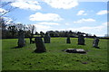
Duloe Stone circle
A ceremonial stone circle, or possibly the remains of a burial cyst.
Image: © Trevor Harris
Taken: 5 Apr 2017
0.20 miles
10
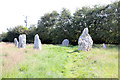
Duloe stone circle, B3254, Duloe
Scheduled Monument. The circle was originally bisected by a hedge which was removed in 1858 and in 1863 three stones were re-erected and a Bronze Age ribbon-handled urn, containing cremated human bones, was found at the base of the NNE stone during a vain attempt to raise the broken stone. There is some discrepancy over accounts of this discovery - whether the urn was found beneath the fallen stone or recovered from the hedge that bisected the site. WC Borlase inferred from the discovery that there may have been a raised mound or stony cairn within the circle and it does seem reasonable to interpret the monument as the impressive kerb or peristalith of an imposing Bronze Age burial monument. The stones do roughly align to the points of the compass suggesting a possible ceremonial observance of astronomical events. Later smaller stones have been added although it is unclear when these date to.
Image: © Jo and Steve Turner
Taken: 27 Jun 2019
0.20 miles