IMAGES TAKEN NEAR TO
Trehunist, LISKEARD, PL14 3SD
Introduction
This page details the photographs taken nearby to PL14 3SD by members of the Geograph project.
The Geograph project started in 2005 with the aim of publishing, organising and preserving representative images for every square kilometre of Great Britain, Ireland and the Isle of Man.

There are currently over 7.5m images from over14,400 individuals and you can help contribute to the project by visiting https://www.geograph.org.uk
Image Map
Images are licensed for reuse under creativecommons.org/licenses/by-sa/2.0
Notes
- Clicking on the map will re-center to the selected point.
- The higher the marker number, the further away the image location is from the centre of the postcode.
Image Listing (9 Images Found)
Images are licensed for reuse under creativecommons.org/licenses/by-sa/2.0
Image
Details
Distance
1
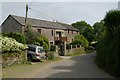
The Barn, Trehunist
The Barn, in the tiny hamlet of Trehunist, south east Cornwall.
Image: © Kevin Hale
Taken: 10 Jun 2006
0.06 miles
2
Trehunist
Seen from the lane from Tilland, crossing a dip on the ridge between the Tiddy and Hay Lake valleys.
Image: © Derek Harper
Taken: 4 Nov 2013
0.09 miles
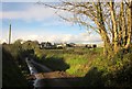
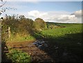
3
Junction at Trehunist
The lane from Tilland passes a tiny lane to Haye which fords the Hay Lake.
Image: © Derek Harper
Taken: 4 Nov 2013
0.12 miles
4
Field, Trehunist
The field to the right of the camera in Image], with the lane to Tilland on the right. Image] was taken by the tree on the left side of the lane, also shown in Image
Image: © Derek Harper
Taken: 4 Nov 2013
0.16 miles
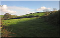
5
Field, Trehunist
Beside the lane to Haye, looking across the field also shown in Image
Image: © Derek Harper
Taken: 4 Nov 2013
0.16 miles
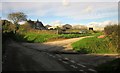
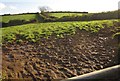
6
Field entrance near Trehunist
Muddy ruts at the gateway on the left of Image
Image: © Derek Harper
Taken: 4 Nov 2013
0.18 miles
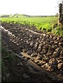
7
Muddy gateway near Trehunist
On the other side of the lane shown in Image] from Image The Hay Lake valley, and the farm at Haye (in Image) are in the background.
Image: © Derek Harper
Taken: 4 Nov 2013
0.18 miles
8
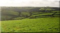
Farmland around Trehunist
Looking right across the square from the same gateway as Image], over the Hay Lake valley. The lane (shown in Image]) is approaching Trehunist; beyond is the Tiddy valley. We're nearly facing into the sun, hence the light entering the lens.
Image: © Derek Harper
Taken: 4 Nov 2013
0.19 miles
9
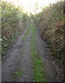
Lane to Haye
A lane that seems to have been abandoned by the highway authority, though it still appears in yellow on the 1:25000 and 1:50000 maps.
Image: © Derek Harper
Taken: 4 Nov 2013
0.23 miles