IMAGES TAKEN NEAR TO
No Mans Land, LOOE, PL13 1QR
Introduction
This page details the photographs taken nearby to PL13 1QR by members of the Geograph project.
The Geograph project started in 2005 with the aim of publishing, organising and preserving representative images for every square kilometre of Great Britain, Ireland and the Isle of Man.

There are currently over 7.5m images from over14,400 individuals and you can help contribute to the project by visiting https://www.geograph.org.uk
Image Map
Images are licensed for reuse under creativecommons.org/licenses/by-sa/2.0
Notes
- Clicking on the map will re-center to the selected point.
- The higher the marker number, the further away the image location is from the centre of the postcode.
Image Listing (8 Images Found)
Images are licensed for reuse under creativecommons.org/licenses/by-sa/2.0
Image
Details
Distance
1
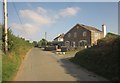
Higher Treveria Cottages
The no through road to Treveria passes these semi-detached cottages as it nears the edge of the square.
Image: © Derek Harper
Taken: 10 Sep 2014
0.01 miles
2
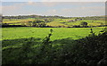
Farmland near Treveria
From further along the no through road shown in Image], looking to the left, with farms at Trenean, and Widegates on the horizon.
Image: © Derek Harper
Taken: 10 Sep 2014
0.09 miles
3
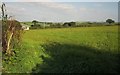
Farmland near Treveria
On the other side of the lane from Image], with the Victorian Lower Treveria Farmhouse http://list.historicengland.org.uk/resultsingle.aspx?uid=1329343&searchtype=mapsearch visible through the gateway on the left.
Image: © Derek Harper
Taken: 10 Sep 2014
0.13 miles
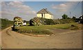
4
Houses at No Man's Land
Along Bucklawren Road, with a little side turning down a private road to Pethick Cottage and Little Pethick.
Image: © Derek Harper
Taken: 10 Sep 2014
0.19 miles
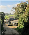
5
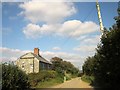
End of the lane at Treveria
The public road ends here, but a route with public access turns right through the farmyard, leading to a bridleway. On the right is Lower Treveria Farmhouse http://list.historicengland.org.uk/resultsingle.aspx?uid=1329343&searchtype=mapsearch .
Image: © Derek Harper
Taken: 10 Sep 2014
0.20 miles
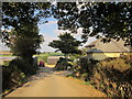
6
Junction, No Man's Land
A small lane turns off to the left towards Treveria from Bucklawren Road, with a house in the angle.
Image: © Derek Harper
Taken: 10 Sep 2014
0.20 miles
7
Barns at Treveria
The conclusion of a route with public access, the one followed by Bill in Image Just behind the camera is the start of bridleway 630/5/1 to Trelowia.
Image: © Derek Harper
Taken: 10 Sep 2014
0.21 miles
8
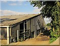
Barn at Treveria
The barn can be seen in Image
Image: © Derek Harper
Taken: 10 Sep 2014
0.22 miles