IMAGES TAKEN NEAR TO
Notte Street, PLYMOUTH, PL1 2BT
Introduction
This page details the photographs taken nearby to Notte Street, PL1 2BT by members of the Geograph project.
The Geograph project started in 2005 with the aim of publishing, organising and preserving representative images for every square kilometre of Great Britain, Ireland and the Isle of Man.

There are currently over 7.5m images from over14,400 individuals and you can help contribute to the project by visiting https://www.geograph.org.uk
Image Map
Images are licensed for reuse under creativecommons.org/licenses/by-sa/2.0
Notes
- Clicking on the map will re-center to the selected point.
- The higher the marker number, the further away the image location is from the centre of the postcode.
Image Listing (1921 Images Found)
Images are licensed for reuse under creativecommons.org/licenses/by-sa/2.0
Image
Details
Distance
1
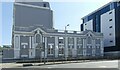
Lockyer Court, Notte Street facade
This is a 20th century addition to the original 19th century villas https://www.geograph.org.uk/photo/7535188 , all Listed Grade II.
Image: © Alan Murray-Rust
Taken: 29 Jun 2023
0.03 miles
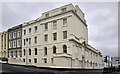
2
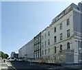
Lockyer Court, Lockyer Street facade
Lockyer Court comprises the first two villas on the right, at some stage converted to an orphanage, later hospital. Listed Grade II. The terrace was originally complete but largely destroyed in the blitz of 1941. part of an important planned group of terraces and villas by Foulston and his pupil Wightwick on the Hoe, a scheme which placed Plymouth in the forefront of town planning in the early/mid C19.
Image: © Alan Murray-Rust
Taken: 29 Jun 2023
0.03 miles
3
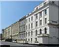
9-15 Lockyer Street, Plymouth
Late Georgian or early Victorian. Not many houses of this vintage survive in Plymouth, and the survivors tend to be huddled in small isolated groups. This group is much rebuilt and includes modern infill. Grade II listed.
Image: © Stephen Richards
Taken: 15 Jun 2014
0.03 miles
4
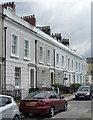
1-11 Alfred Street, Plymouth
A pleasant stuccoed group dating probably from c1820, and possibly the work of John Foulston who laid out much of the area. Grade II listed.
Image: © Stephen Richards
Taken: 15 Jun 2014
0.03 miles
8
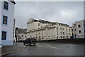
Site of the Lockyer Street Hospital - Plymouth
Purchased and converted into a hospital in 1893 the building reverted to its original use during the 1970's and is now an apartment block.
Image: © Mick Lobb
Taken: 1 May 2010
0.04 miles
9
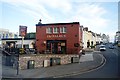
Alfred Street, Plymouth
A street behind the Hoe, with many bed and breakfast hotels.
Image: © Pierre Terre
Taken: 26 Sep 2009
0.04 miles
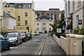
10

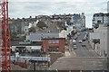
Plymouth : Princess Way & Notte Street
A road junction between the two roads. Plymouth Civic Centre can be seen in the background and so can the Theatre Royal Car Park.
Image: © Lewis Clarke
Taken: 8 Aug 2007
0.04 miles