IMAGES TAKEN NEAR TO
Grassmere Way, SALTASH, PL12 6XE
Introduction
This page details the photographs taken nearby to Grassmere Way, PL12 6XE by members of the Geograph project.
The Geograph project started in 2005 with the aim of publishing, organising and preserving representative images for every square kilometre of Great Britain, Ireland and the Isle of Man.

There are currently over 7.5m images from over14,400 individuals and you can help contribute to the project by visiting https://www.geograph.org.uk
Image Map (Loading...)


Getting Data...Please wait
Leaflet Map data © OpenStreetMap
Images are licensed for reuse under creativecommons.org/licenses/by-sa/2.0
Notes
- Clicking on the map will re-center to the selected point.
- The higher the marker number, the further away the image location is from the centre of the postcode.
Image Listing (20 Images Found)
Images are licensed for reuse under creativecommons.org/licenses/by-sa/2.0
Image
Details
Distance
1
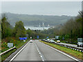
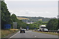
A38 towards Saltash and Plymouth
The stretch of water ahead is the Hamoaze, the estuarine stretch of the tidal River Tamar, between its confluence with the River Lynher and Plymouth Sound.
Image: © David Dixon
Taken: 13 Apr 2022
0.03 miles
2
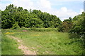
Noisy Green Oasis
By the start of a bridleway to Carkeel, this little green triangle looks nice but the noise from the A38 road just to the right is very loud.
Image: © Tony Atkin
Taken: 25 May 2008
0.05 miles
4
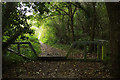
Gate, Pill Lane
This seems to mark the spot at which the route with public access from the east becomes bridleway 636 9/1, whose line soon veers right to run beside the A38. The character of the right of way also changes from a fairly wide and level green lane to a climbing narrow footpath, frequently occupied by a small stream. This gate can be made out in Image], and is a match for the one shown in Image] at the other end of the bridleway.
Image: © Derek Harper
Taken: 19 Oct 2019
0.06 miles
5
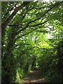
Pill Lane
A reverse view of Image, with a route with public access following the green lane as a continuation of bridleway 636/9/1.
Image: © Derek Harper
Taken: 7 Jun 2013
0.08 miles
6
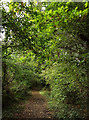
Pill Lane
Heading towards the point where bridleway 636 9/1 takes over.
Image: © Derek Harper
Taken: 19 Oct 2019
0.08 miles
7
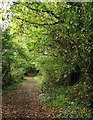
Pill Lane
A route with public access continues the line of bridleway 636 9/1.
Image: © Derek Harper
Taken: 19 Oct 2019
0.08 miles
8
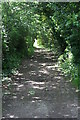
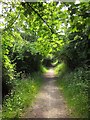
Green Lane near Pill Farm
A lane with an unmetalled surface completely enclosed in green.
Image: © Tony Atkin
Taken: 25 May 2008
0.08 miles
9
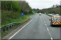
Saltash : The A38
Heading along the A38 as it heads across the northern side of Saltash.
Image: © Lewis Clarke
Taken: 17 Jul 2015
0.09 miles
10
Bridleway to Pill Lane
A little further down bridleway 636/9/1 shown in Image
Image: © Derek Harper
Taken: 7 Jun 2013
0.12 miles