IMAGES TAKEN NEAR TO
Buttlegate, TORPOINT, PL11 3NQ
Introduction
This page details the photographs taken nearby to Buttlegate, PL11 3NQ by members of the Geograph project.
The Geograph project started in 2005 with the aim of publishing, organising and preserving representative images for every square kilometre of Great Britain, Ireland and the Isle of Man.

There are currently over 7.5m images from over14,400 individuals and you can help contribute to the project by visiting https://www.geograph.org.uk
Image Map
Images are licensed for reuse under creativecommons.org/licenses/by-sa/2.0
Notes
- Clicking on the map will re-center to the selected point.
- The higher the marker number, the further away the image location is from the centre of the postcode.
Image Listing (15 Images Found)
Images are licensed for reuse under creativecommons.org/licenses/by-sa/2.0
Image
Details
Distance
1
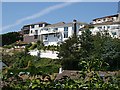
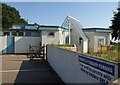
New Houses at Downderry
These houses have been built high above the village on the steep cliff slope. Here the foundations are of hard Devonian slates and not the soft glacial head deposits found lower in the village.
Image: © Tony Atkin
Taken: 17 Jul 2006
0.04 miles
2
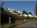
Buttlegate, Downderry
A view of the housing shown in Image from the B3247 below. The cul-de-sac twists around two hairpins to reach the upper row of houses.
Image: © Derek Harper
Taken: 2 Oct 2011
0.06 miles
4
B3247 in Downderry
A scene near the eastern edge of Downderry. Main Road is just passing the school on the left. On the immediate right are Coombe Park Bungalows. Just past the junction is the church more clearly shown in Image
Alternative routes exist for the South West Coast Path from here. A low tide route leaves the road past the school and uses the beach for a mile to Seaton. Or you can follow the B road through the centre of Downderry. We went left.
Image: © Derek Harper
Taken: 2 Oct 2011
0.11 miles
5
St Nicolas Church of England Primary School, Downderry
The school, seen here from the South West Coast Path, following 641/12/1 to the beach, dates from 1961. Note the sign: "Parent and toddler parking: to be used by parents with sleeping toddlers ONLY". I suppose a really mean parent who found the spaces full could wake someone else's toddler up ...
Image: © Derek Harper
Taken: 2 Oct 2011
0.12 miles
6

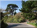
Hairpin Bend
Near the bottom of Tregunnus Lane the road doubles back on itself as it looses height rapidly before entering Downderry. This is not a place to come off the road, there is nothing but a cliff beyond the edge.
Image: © Tony Atkin
Taken: 17 Jul 2006
0.13 miles
7
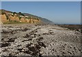
Beach, Downderry
Coarse grey sand and shingle at Downderry, above a wide wave-cut platform. On the left are the cliffs shown in Image, with houses above, many of them currently less than 20 metres from the cliff edge.
The Coast path, or at least a tidal variant of it, runs along the beach.
Image: © Derek Harper
Taken: 2 Oct 2011
0.14 miles
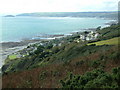
8

Road into Downderry
Road into Downderry, Looe can be seen in the distance.
Image: © Philip Halling
Taken: 16 Apr 2011
0.14 miles
9
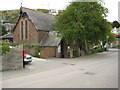
Downderry church
St Nicholas church, Downderry.
Image: © Philip Halling
Taken: 16 Apr 2011
0.15 miles
10
Hairpin bend, B3247
A reverse view of Image Here (by the wheelie bin) the South West Coast Path, climbing away eastwards from Downderry, leaves the B road and starts a long ascent (see Image).
Image: © Derek Harper
Taken: 2 Oct 2011
0.16 miles