IMAGES TAKEN NEAR TO
Coombe Park, TORPOINT, PL10 1NY
Introduction
This page details the photographs taken nearby to Coombe Park, PL10 1NY by members of the Geograph project.
The Geograph project started in 2005 with the aim of publishing, organising and preserving representative images for every square kilometre of Great Britain, Ireland and the Isle of Man.

There are currently over 7.5m images from over14,400 individuals and you can help contribute to the project by visiting https://www.geograph.org.uk
Image Map (Loading...)


Getting Data...Please wait
Leaflet Map data © OpenStreetMap
Images are licensed for reuse under creativecommons.org/licenses/by-sa/2.0
Notes
- Clicking on the map will re-center to the selected point.
- The higher the marker number, the further away the image location is from the centre of the postcode.
Image Listing (7 Images Found)
Images are licensed for reuse under creativecommons.org/licenses/by-sa/2.0
Image
Details
Distance
1
Barracks Road
The road closed signs are temporarily removed for the May bank holidays in the village.
Image: © Jay Pea
Taken: 7 May 2018
0.22 miles
2
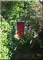
Red door, Kingsand
Seen from footpath 617 28/1, but not on it. The tiny path climbs round the north end of the village to meet Devonport Hill.
Image: © Derek Harper
Taken: 8 Aug 2015
0.23 miles
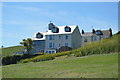
3
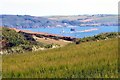
Plymouth Sound
Showing the Plymouth Breakwater, and Fort.
Image: © Peter Jeffery
Taken: 2 Jul 2014
0.23 miles
4
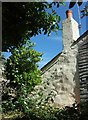
Cottage, Kingsand
Seen from footpath 617 28/1, and perhaps next door to Image
Image: © Derek Harper
Taken: 8 Aug 2015
0.24 miles
5
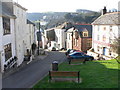
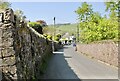
The Green, Kingsand
The Green at Kingsand with the Rising Sun Inn on the right and Cawsand Fort in the distance
Image: © Darren Rosson
Taken: 5 Feb 2007
0.24 miles
7
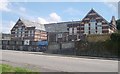
Fourlanesend School
This is the local primary school for the Rame Peninsula. The name comes from its situation on the high ground between Kingsand/Cawsand and Millbrook at the junction of four (or five?) lanes.
Image: © Tony Atkin
Taken: 12 Aug 2005
0.25 miles