IMAGES TAKEN NEAR TO
Pier Lane, TORPOINT, PL10 1LP
Introduction
This page details the photographs taken nearby to Pier Lane, PL10 1LP by members of the Geograph project.
The Geograph project started in 2005 with the aim of publishing, organising and preserving representative images for every square kilometre of Great Britain, Ireland and the Isle of Man.

There are currently over 7.5m images from over14,400 individuals and you can help contribute to the project by visiting https://www.geograph.org.uk
Image Map
Images are licensed for reuse under creativecommons.org/licenses/by-sa/2.0
Notes
- Clicking on the map will re-center to the selected point.
- The higher the marker number, the further away the image location is from the centre of the postcode.
Image Listing (214 Images Found)
Images are licensed for reuse under creativecommons.org/licenses/by-sa/2.0
Image
Details
Distance

3
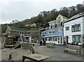
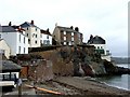
The Bound, Cawsand
This very short street bordering Cawsand Beach is called The Bound. At the far end can be seen the Cawsand Bay Hotel - their website here http://www.thecawsandbayhotel.co.uk
Image: © Rob Farrow
Taken: 25 Jan 2014
0.03 miles
4
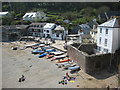
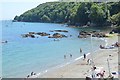
Beach at Cawsand
Looking down on the beach in Cawsand from the road to Kingsand.
Image: © Philip Halling
Taken: 17 Apr 2011
0.03 miles
5
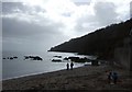
Cawsand beach
Completely in the shade with the sun low in the sky in early December and deserted compared with Tony Atkin's April photo Image
Image: © Rod Allday
Taken: 6 Dec 2009
0.04 miles
7
Cawsand - from Cawsand Beach
The houses are on Garrett Street as it climbs from the Square in Cawsand. A passenger ferry runs in the summer from this beach to the Mayflower Steps in Plymouth across Plymouth Sound. The ferry trip takes half-an-hour or so and can be quite choppy.
Image: © Rob Farrow
Taken: 2 Apr 2006
0.04 miles
8
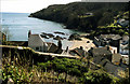
Cawsand Beach - Looking towards Pier Cellars
Pier Cellars is a Royal Naval establishment halfway between Cawsand and Penlee Point. I think that it specialises in diving training. RN ships often hoot as they pass.
Image: © Rob Farrow
Taken: 2 Apr 2006
0.04 miles
10
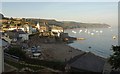
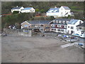
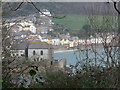
Cawsand from Pier Lane
A view from the coast path entering Cawsand from the southeast, looking across the beach to houses on Garrett Street. The boats moored in the evening sunlight are off Kingsand.
Image: © Derek Harper
Taken: 1 Oct 2011
0.04 miles