IMAGES TAKEN NEAR TO
Lower Anderton, TORPOINT, PL10 1HR
Introduction
This page details the photographs taken nearby to Lower Anderton, PL10 1HR by members of the Geograph project.
The Geograph project started in 2005 with the aim of publishing, organising and preserving representative images for every square kilometre of Great Britain, Ireland and the Isle of Man.

There are currently over 7.5m images from over14,400 individuals and you can help contribute to the project by visiting https://www.geograph.org.uk
Image Map (Loading...)


Getting Data...Please wait
Leaflet Map data © OpenStreetMap
Images are licensed for reuse under creativecommons.org/licenses/by-sa/2.0
Notes
- Clicking on the map will re-center to the selected point.
- The higher the marker number, the further away the image location is from the centre of the postcode.
Image Listing (8 Images Found)
Images are licensed for reuse under creativecommons.org/licenses/by-sa/2.0
Image
Details
Distance
1
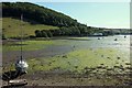
Millbrook Lake
This inlet on the estuary at Lower Anderton has a pair of embankments that jut out - one can be seen on the far side here. Behind it rise the steep Clarrick Woods. View from footpath 617 37/2.
Image: © Derek Harper
Taken: 8 Aug 2015
0.09 miles
2
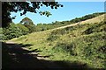
Track to Nanny Parson's Grove
Brielfy followed by footpath 617 37/3 which then veers off to the right uphill across the meadow shown in Image
Image: © Derek Harper
Taken: 8 Aug 2015
0.11 miles
4

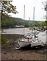
Millbrook lake
Looking across Millbrook Lake.
Image: © Jay Pea
Taken: 6 May 2018
0.15 miles
5
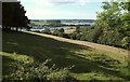
Field beside Nanny Parson's Grove
Footpath 617 37/3 cuts down through a meadow between woods (Nanny Parson's Grove is on the right) to cross the lane along the southern side of Millbrook Lake, the inlet seen ahead. Who was Nanny Parson?
Image: © Derek Harper
Taken: 8 Aug 2015
0.17 miles
6
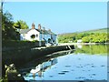
Row of cottage s
Lower Anderson Road and cottages.
Image: © Jay Pea
Taken: 6 May 2018
0.19 miles
7
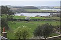
View across Mount Edgcumbe farmland
Taken from the pop deck of a bus. The remains of Mount Edgcumbe mill can be seen towards the right.
Image: © Trevor Harris
Taken: 4 Apr 2017
0.25 miles
8
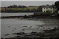
House overlooking Millbrook Lake
House overlooking Millbrook Lake, part of the tamar estuary, at Low tide.
Image: © Philip Halling
Taken: 24 Feb 2009
0.25 miles