IMAGES TAKEN NEAR TO
Kiln Close, TORPOINT, PL10 1FG
Introduction
This page details the photographs taken nearby to Kiln Close, PL10 1FG by members of the Geograph project.
The Geograph project started in 2005 with the aim of publishing, organising and preserving representative images for every square kilometre of Great Britain, Ireland and the Isle of Man.

There are currently over 7.5m images from over14,400 individuals and you can help contribute to the project by visiting https://www.geograph.org.uk
Image Map (Loading...)


Getting Data...Please wait
Leaflet Map data © OpenStreetMap
Images are licensed for reuse under creativecommons.org/licenses/by-sa/2.0
Notes
- Clicking on the map will re-center to the selected point.
- The higher the marker number, the further away the image location is from the centre of the postcode.
Image Listing (14 Images Found)
Images are licensed for reuse under creativecommons.org/licenses/by-sa/2.0
Image
Details
Distance
1
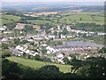
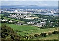
Millbrook
This photograph was taken from the viewpoint on Maker Heights overlooking the village (SX430516)
Image: © Tony Atkin
Taken: 12 Aug 2005
0.07 miles
2
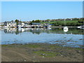
Millbrook boatyard
The boatyard nearest to the dam at Millbrook, with the creek nearly at high tide and brilliant sunshine it is ideal for reflections.
Image: © Jay Pea
Taken: 6 May 2018
0.07 miles
3

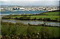
View over Pottery Estate
From Blindwell Hill, looking towards St John's Lake and Sango Point, with Torpoint across the water, and Devonport away on the right. In the distance is Dartmoor.
Image: © Derek Harper
Taken: 11 May 2019
0.14 miles
4
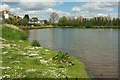
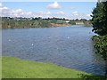
Lake, Millbrook
"The Lake was created when the tidal creek was dammed in 1981, following regular flooding of the village in the 1970’s ... a sluice in the dam prevents the lake from over filling" http://www.millbrook-pc.gov.uk/village-amenities/lake-park/ .
Image: © Derek Harper
Taken: 11 May 2019
0.15 miles
5
To Insworke Barton
Insworke Barton is the ruined farm in the centre, no the northern edge of Millbrook. This view looks right from the same place as Image], with a distant view of Plymouth on the right.
Image: © Derek Harper
Taken: 11 May 2019
0.16 miles
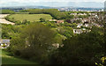
6
Devonport from near Millbrook, Cornwall
Contrasting rural landscape on the Torpoint side of the Tamar
Image: © Crispin Purdye
Taken: Unknown
0.18 miles
7
Freshwater Lake, Millbrook
The upper end of the tidal creek leading to Millbrook was dammed producing this pleasant freshwater lake.
Image: © Tony Atkin
Taken: 12 Aug 2005
0.20 miles
8
Millbrook from Whitesand Bay Battery
Taken from the same point as Image] but zoomed in more onto the village of Millbrook - hence making it the subject of the photo. Beyond the village can be seen the extensive city of Plymouth and in the distance rise the hills of Dartmoor.
Image: © Rob Farrow
Taken: 8 Aug 2008
0.20 miles
9

Cattle near Millbrook
Looking left from where Image] was taken, with St John's Lake and HMS Raleigh across it in the centre.
Image: © Derek Harper
Taken: 11 May 2019
0.20 miles
10

Junction near Millbrook
A triangle of trees and bushes is enclosed by the lanes to Penhale (left), Insworks (right) and Millbrook (behind camera).
Image: © Derek Harper
Taken: 11 May 2019
0.22 miles