IMAGES TAKEN NEAR TO
Rowan Drive, FORT WILLIAM, PH33 7EG
Introduction
This page details the photographs taken nearby to Rowan Drive, PH33 7EG by members of the Geograph project.
The Geograph project started in 2005 with the aim of publishing, organising and preserving representative images for every square kilometre of Great Britain, Ireland and the Isle of Man.

There are currently over 7.5m images from over14,400 individuals and you can help contribute to the project by visiting https://www.geograph.org.uk
Image Map
Images are licensed for reuse under creativecommons.org/licenses/by-sa/2.0
Notes
- Clicking on the map will re-center to the selected point.
- The higher the marker number, the further away the image location is from the centre of the postcode.
Image Listing (11 Images Found)
Images are licensed for reuse under creativecommons.org/licenses/by-sa/2.0
Image
Details
Distance
1
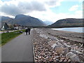
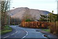
Sign for the Great Glen Way and Fort William
Having left the shore of Loch Linnhe, a stretch of road walking follows next but with the familiar profile of Ben Nevis ahead. The route leaves the road at the Soldier's Bridge.
Image: © Peter S
Taken: 3 Jun 2023
0.11 miles
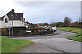
3
Glenmallie Road, Caol
The Great Glen Way follows this road around to the shore of Loch Linnhe to reach the Caledonian Canal at Corpach.
Image: © Jim Barton
Taken: 15 Nov 2014
0.17 miles
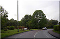
4
B8006 road to Caol
The road follows the N bank of the River Lochy. In the background is the ridge of Meall an t-Slamain across Loch Linnhe.
Image: © Jim Barton
Taken: 15 Nov 2014
0.18 miles
5
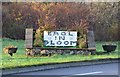
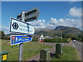
Caol in Bloom
Roadside sign by the B8006.
Image: © Jim Barton
Taken: 15 Nov 2014
0.18 miles
6
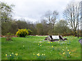
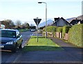
Caol in Bloom
The grassed area with daffodils is beside the B8006 entering Caol from the south.
Image: © Trevor Littlewood
Taken: 25 Apr 2017
0.18 miles
7

Entering the quietly attractive suburb of Caol
The sign is surrounded by cuckoo flowers
Image: © Tim Heaton
Taken: 3 May 2017
0.19 miles
8
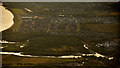
Caol and Lochyside, Scottish Highlands
The urban conurbations of Caol and Lochyside, Fort william, Scottish Highlands. To the left is Loch Linnhe, a tidal loch. The water 'above' Caol is the Caledonian Canal. The water 'below' is the River Lochy, which has a large island within its estuary.
Image: © Andrew Tryon
Taken: 30 Jul 2019
0.22 miles
9
Junction of Erracht Terrace and Glenmallie Road, Caol
Image: © Steven Brown
Taken: 5 Nov 2010
0.24 miles