IMAGES TAKEN NEAR TO
Perth Place, FORT WILLIAM, PH33 6UL
Introduction
This page details the photographs taken nearby to Perth Place, PH33 6UL by members of the Geograph project.
The Geograph project started in 2005 with the aim of publishing, organising and preserving representative images for every square kilometre of Great Britain, Ireland and the Isle of Man.

There are currently over 7.5m images from over14,400 individuals and you can help contribute to the project by visiting https://www.geograph.org.uk
Image Map
Images are licensed for reuse under creativecommons.org/licenses/by-sa/2.0
Notes
- Clicking on the map will re-center to the selected point.
- The higher the marker number, the further away the image location is from the centre of the postcode.
Image Listing (19 Images Found)
Images are licensed for reuse under creativecommons.org/licenses/by-sa/2.0
Image
Details
Distance
1
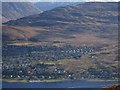
Upper Auchintore
Fort William, seen from across Loch Linnhe.
Image: © Richard Webb
Taken: 17 Feb 2013
0.09 miles
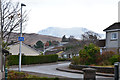
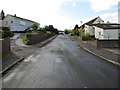
2
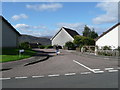
Housing estate above Fort William
Stirling Place from Lochaber Road.
Image: © Hector Davie
Taken: 14 Sep 2007
0.10 miles
3
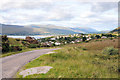
View over Upper Achintore, Fort William
Image: © Steven Brown
Taken: 24 Aug 2010
0.11 miles
4
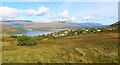
Fort William and Loch Linnhe
Seen from Blarmachfoldach viewpoint on Lundavra Road.
Image: © Bill Kasman
Taken: 23 Sep 2020
0.11 miles
5
Ben Nevis in the back garden
Perhaps a slight exaggeration, but the snow-covered Carn Dearg makes a bold skyline for the houses in Upper Auchintore seen from Lundavra Road.
Image: © Jim Barton
Taken: 16 Nov 2019
0.15 miles
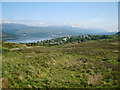
6
Fort William: view over the town from Blarmachfoldach
Looking north from Image across the town and Loch Linnhe.
Image: © Chris Downer
Taken: 7 Aug 2012
0.18 miles
7
Above Fort William
From the pic nic area and viewpoint above the town on the road to Blarmachfoldach
Image: © Michael Graham
Taken: 7 Jun 2008
0.18 miles
8
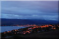
Fort William Evening.
On a little road that heads southeast out of Fort William, I found a nice little car park with a view over town.
Image: © Peter Allen
Taken: 28 Aug 2008
0.19 miles
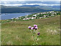
9
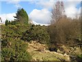
Burn, Upper Auchintore
Whins alongside a burn. This is currently the edge of built up Fort William. The distant snow is on Ben Nevis.
Image: © Richard Webb
Taken: 16 Mar 2008
0.19 miles
10
Cromarty Crescent in Fort William
Looking south-westward.
Image: © Peter Wood
Taken: 24 Sep 2019
0.19 miles