IMAGES TAKEN NEAR TO
Moncreiffe Island, PERTH, PH2 8NR
Introduction
This page details the photographs taken nearby to Moncreiffe Island, PH2 8NR by members of the Geograph project.
The Geograph project started in 2005 with the aim of publishing, organising and preserving representative images for every square kilometre of Great Britain, Ireland and the Isle of Man.

There are currently over 7.5m images from over14,400 individuals and you can help contribute to the project by visiting https://www.geograph.org.uk
Image Map
Images are licensed for reuse under creativecommons.org/licenses/by-sa/2.0
Notes
- Clicking on the map will re-center to the selected point.
- The higher the marker number, the further away the image location is from the centre of the postcode.
Image Listing (98 Images Found)
Images are licensed for reuse under creativecommons.org/licenses/by-sa/2.0
Image
Details
Distance
1
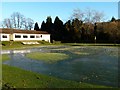
Better curling than putting
The 18th green of the King James VI golf course on Moncreiff Island in the river Tay submerged in frozen water.
Image: © James Allan
Taken: 10 Dec 2012
0.03 miles
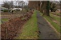
2
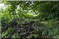
Path on Moncrieffe Island
A faint path, presumably used by anglers, on the western edge of Moncrieffe Island in the River Tay. The path is very overgrown, and there are many invasive species of plant including giant hogweed, Himalayan balsam, gunnera and Japanese Knotweed.
NHS UK warns that "If the sap of this plant comes into contact with your skin, it can cause severe, painful burns and make your skin sensitive to strong sunlight."
Reference: http://www.nhs.uk/LiveWell/bites-and-stings/Pages/Plant-dangers-garden-countryside.aspx
Image: © William Starkey
Taken: 16 Jun 2014
0.04 miles
3
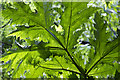
Giant hogweed growing by the River Tay
Detail view of a giant hogweed leaf - many of these invasive plants grow on Moncrieffe Island in the River Tay.
NHS UK warns that "If the sap of this plant comes into contact with your skin, it can cause severe, painful burns and make your skin sensitive to strong sunlight."
Reference: http://www.nhs.uk/LiveWell/bites-and-stings/Pages/Plant-dangers-garden-countryside.aspx
Image: © William Starkey
Taken: 16 Jun 2014
0.07 miles
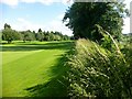
4
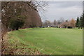
Golf Course
King James VI Golf Course on Moncrieffe Island, looking north towards the club house,the embankment and trees on the left are to keep The River Tay off the golf course, it doesn't always work!
Image: © Paul McIlroy
Taken: 3 Jan 2007
0.08 miles
5
Moncreiffe Island
This small embankment and line of trees is a flood defence against The River Tay on Moncreiffe Island,it doesn't always work as can be seen by the amount of debris deposited against the fence of the allotments belonging to The Perth Working Men's Garden Association.
Image: © Paul McIlroy
Taken: 3 Jan 2007
0.08 miles
6
Moncreiffe Island
A view down the overgrown levee on the west side of Moncreiffe Island with the grassland of the King James VI Golf Course to the east of the levee.
Image: © Rude Health
Taken: 22 Jul 2015
0.08 miles
7
Willowgate channel
This channel of the Tay runs to the east of Moncreiffe Island.
The plant in the foreground is Japanese Knotweed, which has colonised a long stretch of the bank here.
Image: © Rob Burke
Taken: 29 Oct 2011
0.08 miles
8
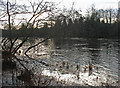
River Tay
The River Tay, swollen by recent wet weather, has submerged the riverside path.
Image: © William Starkey
Taken: 19 Nov 2010
0.10 miles
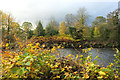
9
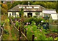
Allotments, Moncreiffe Island
It may be October, but still plenty colour in the allotments
Image: © Jackie Proven
Taken: 13 Oct 2008
0.11 miles
10
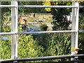
Allotments viewed from railway bridge
Looking across the railway track from the footbridge at the allotments on Moncreiffe Island.
Image: © Lis Burke
Taken: 7 Oct 2007
0.11 miles