IMAGES TAKEN NEAR TO
Muirhall Road, PERTH, PH2 7BQ
Introduction
This page details the photographs taken nearby to Muirhall Road, PH2 7BQ by members of the Geograph project.
The Geograph project started in 2005 with the aim of publishing, organising and preserving representative images for every square kilometre of Great Britain, Ireland and the Isle of Man.

There are currently over 7.5m images from over14,400 individuals and you can help contribute to the project by visiting https://www.geograph.org.uk
Image Map
Images are licensed for reuse under creativecommons.org/licenses/by-sa/2.0
Notes
- Clicking on the map will re-center to the selected point.
- The higher the marker number, the further away the image location is from the centre of the postcode.
Image Listing (29 Images Found)
Images are licensed for reuse under creativecommons.org/licenses/by-sa/2.0
Image
Details
Distance
1
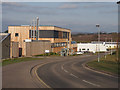
The Hub, Murray Royal Hospital
This is the new main building for this mental hospital, housing the main reception, café, outpatients department and administrative services.
Image: © Rob Burke
Taken: 17 Feb 2013
0.08 miles
2
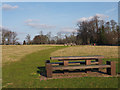
Millennium Park
An area of open parkland with paths and picnic tables, managed by the community council.
Image: © Rob Burke
Taken: 17 Feb 2013
0.10 miles
3
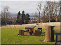
Millennium Park
An area of open parkland with paths and picnic tables, managed by the community council.
Image: © Rob Burke
Taken: 17 Feb 2013
0.12 miles
4

Potterhill Gardens
An area of modern blocks of flats and terraced housing.
Image: © Rob Burke
Taken: 17 Feb 2013
0.13 miles
5
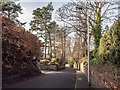
Bowerswell Road
Looking downhill with the entrance to Dupplin Terrace on the left.
This is an area of substantial houses and large gardens. However, the access roads to the area are steep and narrow.
Image: © Rob Burke
Taken: 17 Feb 2013
0.13 miles
6
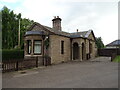
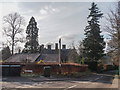
Lodge of Muirhall Road
At the entrance to Pitcullen House.
Image: © JThomas
Taken: 12 Jun 2021
0.16 miles
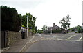
7
Lochie Brae
Steep hill, leaving Perth for Kinnoull Hill and the Murray Royal Hospital. It carries the National Cycle Network route 77.
Image: © Richard Webb
Taken: 25 Aug 2010
0.17 miles
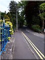
8
Lochie Brae
National Cycle Route 77 uphill from Perth.
Image: © JThomas
Taken: 12 Jun 2021
0.17 miles
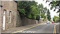
10
Corner of Manse Road and Bowerswell Road
These two roads provide access to an area of substantial houses on the east side of Perth. Neither road is up to standard for modern traffic.
Note the modern communication cabinets, replacing the old telephone pole.
Image: © Rob Burke
Taken: 17 Feb 2013
0.18 miles