IMAGES TAKEN NEAR TO
Skinnergate, PERTH, PH1 5JH
Introduction
This page details the photographs taken nearby to Skinnergate, PH1 5JH by members of the Geograph project.
The Geograph project started in 2005 with the aim of publishing, organising and preserving representative images for every square kilometre of Great Britain, Ireland and the Isle of Man.

There are currently over 7.5m images from over14,400 individuals and you can help contribute to the project by visiting https://www.geograph.org.uk
Image Map
Images are licensed for reuse under creativecommons.org/licenses/by-sa/2.0
Notes
- Clicking on the map will re-center to the selected point.
- The higher the marker number, the further away the image location is from the centre of the postcode.
Image Listing (457 Images Found)
Images are licensed for reuse under creativecommons.org/licenses/by-sa/2.0
Image
Details
Distance
1
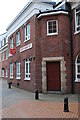
Skinnergate House
The Salvation Army house in Perth. Walking past here as a kid taught me what happened when people become dependent on alcohol.
Image: © william
Taken: 16 Jul 2010
0.00 miles
2
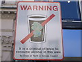
No alcohol consumption sign in Perth City Centre
Image: © Nick Mutton 01329 000000
Taken: 21 Mar 2008
0.02 miles
4
Park World Tour, Perth 2010
The Park World Tour is a series of short fast orienteering races held around the world, often in iconic cities. I believe it may be aiming to get orienteering into the Olympic Games one day - a welcome change from the near monopoly of running around in circles on a carpet.
http://www.nopesport.com/news/1357-park-world-tour-preview
The format is a small race with a top class field, followed by a public race on the same courses. The event used the streets and vennels of Perth.
Image: © Richard Webb
Taken: 11 Sep 2010
0.02 miles
5
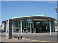
Perth Concert Hall
Completed in summer 2005 at a cost of £17m, the new concert hall houses a 1200 seater auditorium with flexible flooring, staging and seating allowing it to host exhibitions, and conferences as well as orchestral and other musical performances.
Image: © Val Vannet
Taken: 10 May 2006
0.02 miles
6
Old and New
One of the oldest buildings in Perth (The Fair Maid's House) is juxtaposed with one of the newest (the Concert Hall)
Image: © Val Vannet
Taken: 10 May 2006
0.02 miles
7
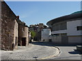
Red Brig
The Town Lade Image runs underground from the City Mills Image but surfaces briefly here before flowing into the Tay. The floodgates to the right of the bridge were installed as part of Perth's flood defences, as water backs up in the lade when the Tay is high.
Image: © Lis Burke
Taken: 4 Feb 2007
0.02 miles
8
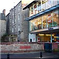
George Inn Lane
George Inn Lane links Mill Street to George Street. The Town Lade runs behind the wall on the left. Note the flood prevention gates.
Image: © Paul McIlroy
Taken: 6 Sep 2007
0.02 miles
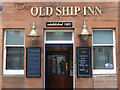
9

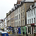
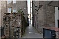
Old Ship Inn, Skinnergate
Perth's oldest pub, mentioned in official records in 1665 but believed to be older. This is because the name reflects the fact that in mediaeval times ships on the Tay used to berth at the east end of the High Street before new wharves were built at the south-east end of the burgh in 1539.
Image: © kim traynor
Taken: 8 Oct 2013
0.03 miles
10
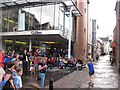
The Old Ship Inn, Perth
Reputedly the oldest pub in Perth, dating back to at least 1665, the Old Ship Inn can be found on Skinnergate just off High Street. Today it is part of the Belhaven (Greene King) estate. The reference to drinking rum before noon seems suitably nautical. See Image for a wider view. Note also the reflection of the photographer inside the door.
Image: © Stephen McKay
Taken: 6 Apr 2019
0.03 miles