IMAGES TAKEN NEAR TO
Pier Road, ABERFELDY, PH15 2HZ
Introduction
This page details the photographs taken nearby to Pier Road, PH15 2HZ by members of the Geograph project.
The Geograph project started in 2005 with the aim of publishing, organising and preserving representative images for every square kilometre of Great Britain, Ireland and the Isle of Man.

There are currently over 7.5m images from over14,400 individuals and you can help contribute to the project by visiting https://www.geograph.org.uk
Image Map
Images are licensed for reuse under creativecommons.org/licenses/by-sa/2.0
Notes
- Clicking on the map will re-center to the selected point.
- The higher the marker number, the further away the image location is from the centre of the postcode.
Image Listing (218 Images Found)
Images are licensed for reuse under creativecommons.org/licenses/by-sa/2.0
Image
Details
Distance
1
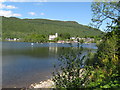
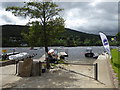
Kenmore village
This is an absolutely delightful village on the shore of Loch Tay.
Image: © Carol Walker
Taken: 30 May 2009
0.00 miles
2
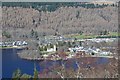
Kenmore from the south
The village seen from the Queen's Drive - compare with Image taken about half an hour earlier.
Image: © Jim Barton
Taken: 17 Mar 2016
0.01 miles
4
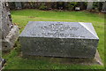
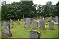
The grave of the son of Maharajah Duleep Singh
In 1865, Maharajah Duleep Singh buried his day old son at Kenmore Parish Church.
The Maharajah was the Sikh empire's last ruler and was exiled to the UK when his kingdom was annexed by the East India Company in 1849.
At its height the Sikh Empire was over twice the size of the United Kingdom and was based around the Punjab region of India.
However, a bloody war with the East India Company saw it eventually annexed and Maharajah Singh was exiled to Britain at the age of 10.
His friendship with Queen Victoria however, led to the former Indian royal moving to Scotland in 1855 under the guidance of his guardian Sir John Login.
It was in Scotland that he converted to Christianity.
Duleep Singh lived at the nearby Castle Menzies Image] between 1855 and 1858, following his exile from the Punjab in 1854.
Image: © Richard Hoare
Taken: 7 Sep 2016
0.03 miles
5
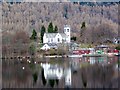
Reflections on Loch Tay
Looking across the eastern end of the loch towards the Church of Scotland at Kenmore.
Image: © Maigheach-gheal
Taken: 29 Mar 2010
0.03 miles
7
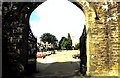
Village of Kenmore
View from the entrance gateway to Taymouth Castle, once the seat of the Marquis of Breadalbane. Kenmore is a very attractive and well kept village at the east of Loch Tay. The present village was laid out by the 3rd Earl of Breadalbane in 1760. He let the inhabitants live rent free on condition that they followed a trade and kept the place clean and tidy. This generous arrangement cut both ways since it ensured he had a core of tradesmen at his bidding! Burns was favourably impressed when he stayed at the Inn during his highland tour and penned some suitable lines.
Image: © ronnie leask
Taken: 15 May 1994
0.03 miles
9
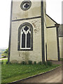
Section of Kenmore Church Tower - OS 1GL Bolt, RHS of tower
Bolt in North-east corner of Kenmore Church Tower; 1.57 ft. above surface [1GL, Leeks to Logierait, Mark No. 34] =?= CUT MARK N ANG CH (ODN 120.9507m, AGL 0.5m).
Image: © thejackrustles
Taken: 20 May 2018
0.04 miles
10
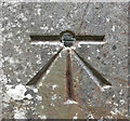
OS 1GL Bolt: Kenmore, Church
Bolt in North-east corner of Kenmore Church Tower; 1.57 ft. above surface [1GL, Leeks to Logierait, Mark No. 34] =?= CUT MARK N ANG CH (ODN 120.9507m, AGL 0.5m).
Image: © thejackrustles
Taken: 20 May 2018
0.04 miles