IMAGES TAKEN NEAR TO
Tippermuir Close, PERTH, PH1 1AD
Introduction
This page details the photographs taken nearby to Tippermuir Close, PH1 1AD by members of the Geograph project.
The Geograph project started in 2005 with the aim of publishing, organising and preserving representative images for every square kilometre of Great Britain, Ireland and the Isle of Man.

There are currently over 7.5m images from over14,400 individuals and you can help contribute to the project by visiting https://www.geograph.org.uk
Image Map
Images are licensed for reuse under creativecommons.org/licenses/by-sa/2.0
Notes
- Clicking on the map will re-center to the selected point.
- The higher the marker number, the further away the image location is from the centre of the postcode.
Image Listing (15 Images Found)
Images are licensed for reuse under creativecommons.org/licenses/by-sa/2.0
Image
Details
Distance
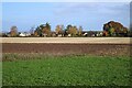
3
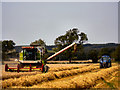
Harvesting on Gloagburn Farm
Joe Niven harvesting barley on one of Gloagburn farm fields during August 2003
Image: © Arthur Bruce
Taken: 8 Aug 2003
0.14 miles
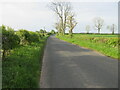
4
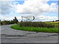
Cottage at Tibbermore Crossroads
This cottage shows on the 1856 Ordnance Survey 1" to the mile map.
Image: © Alan Reid
Taken: 7 Jul 2017
0.16 miles
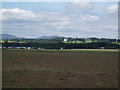
5
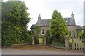
Houses, Tibbermore
Seen from Gloagburn Farm.
Image: © Richard Sutcliffe
Taken: 30 Oct 2023
0.17 miles
8
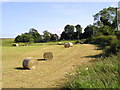
Tibbermore Church & Graveyard
This is a picture taken just after the harvest was taken in showing bales of straw just to the north of Tibbermore Church & Graveyard this Church is no longer in use. Parishioners now use St. Serf's Church at Almondbank.
Image: © Arthur Bruce
Taken: Unknown
0.18 miles
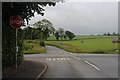
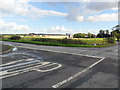
10
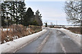
Road to Tibbermore
Minor road heading south from the A85 towards Tibbermore.
Image: © Scott Cormie
Taken: 15 May 2022
0.19 miles