IMAGES TAKEN NEAR TO
Kirkmichael, BLAIRGOWRIE, PH10 7LY
Introduction
This page details the photographs taken nearby to PH10 7LY by members of the Geograph project.
The Geograph project started in 2005 with the aim of publishing, organising and preserving representative images for every square kilometre of Great Britain, Ireland and the Isle of Man.

There are currently over 7.5m images from over14,400 individuals and you can help contribute to the project by visiting https://www.geograph.org.uk
Image Map
Images are licensed for reuse under creativecommons.org/licenses/by-sa/2.0
Notes
- Clicking on the map will re-center to the selected point.
- The higher the marker number, the further away the image location is from the centre of the postcode.
Image Listing (45 Images Found)
Images are licensed for reuse under creativecommons.org/licenses/by-sa/2.0
Image
Details
Distance
1
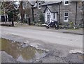
A puddle of tears?
Outside the derelict church in Kirkmichael; but the attractive cottage opposite offered a pleasanter prospect. 'Apres le deluge nous' to misquote Mme de Pompadour.
Image: © Stanley Howe
Taken: 15 May 2014
0.03 miles
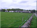
2
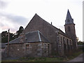
Kirkmichael Primary School
The school and its playing fields are next to the bridge over the river Ardle.
Image: © Lis Burke
Taken: 18 Feb 2006
0.04 miles
3
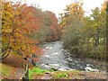
River Ardle riverside walk
This is the start of a signposted riverside walk at Kirkmichael.
Image: © Rob Burke
Taken: 8 Nov 2008
0.04 miles
4
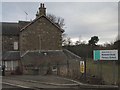
O me miserum!
Former church building in Kirkmichael. A once splendid sacred building, now very unloved and derelict after a succession of commercial enterprise failures.
Image: © Stanley Howe
Taken: 15 May 2014
0.04 miles
5
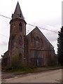
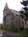
Neglected former church building, Kirkmichael
Image: © Stanley Howe
Taken: 15 May 2014
0.04 miles
6
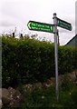
'The Cateran Trail' through Kirkmichael
Spittal of Gleeshee (left 9ml), Bridge of Calley (right 7ml). Signpost by the redundant church building.
Image: © Stanley Howe
Taken: 15 May 2014
0.04 miles
7
Abandoned church, Kirkmichael
We were told locally that this fine old church had been used to store farm machinery after it was completely gutted (there is a large hole in the wall facing the road, blocked by a crude double door). Latterly, it was due to be turned into a dwelling but this seems to have foundered - the economic downturn?
Image: © Karl and Ali
Taken: 21 Sep 2012
0.04 miles
8
'The Cateran Trail' from Bridge of Cally
Entering Kirkmichael alongside the derelict church (left).
Image: © Stanley Howe
Taken: 15 May 2014
0.05 miles
9
A view to Sillerburn, Kirkmichael
From the cemetery road.
Image: © Stanley Howe
Taken: 15 May 2014
0.05 miles
10
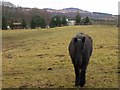
Horse at Kirkmichael
Looking south east across fields at the edge of the village
Image: © Lis Burke
Taken: 18 Feb 2006
0.05 miles