IMAGES TAKEN NEAR TO
Drumbeg Road, BISHOPTON, PA7 5GT
Introduction
This page details the photographs taken nearby to Drumbeg Road, PA7 5GT by members of the Geograph project.
The Geograph project started in 2005 with the aim of publishing, organising and preserving representative images for every square kilometre of Great Britain, Ireland and the Isle of Man.

There are currently over 7.5m images from over14,400 individuals and you can help contribute to the project by visiting https://www.geograph.org.uk
Image Map
Images are licensed for reuse under creativecommons.org/licenses/by-sa/2.0
Notes
- Clicking on the map will re-center to the selected point.
- The higher the marker number, the further away the image location is from the centre of the postcode.
Image Listing (12 Images Found)
Images are licensed for reuse under creativecommons.org/licenses/by-sa/2.0
Image
Details
Distance
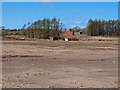
1
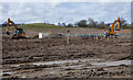
Former ROF Bishopton site
Ground works to the west of Slateford Road.
Image: © Thomas Nugent
Taken: 16 Apr 2018
0.11 miles
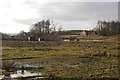
2
Royal Ordnance Factory, Bishopton
Some of the abandoned infrastructure where part of the site is being redeveloped as housing.
Image: © Richard Webb
Taken: 12 Dec 2015
0.13 miles
3
Former Royal Ordnance Factory site
ROF Bishopton is being partly redeveloped for housing.
Image: © Richard Webb
Taken: 12 Dec 2015
0.16 miles
4
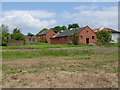
Ingliston Farm
The farmhouse is in the distance with the red-brick chimneys. The other buildings surrounding it were part of the former Royal Ordnance Factory at Bishopton which effectively took over and adapted the buildings on site as part of the process of manufacturing armament propellants. BAE Systems now operate this site and are preparing it for a gradual handover to civilian use. With thanks to BAE Site Remediation for access.
Image: © Raymond Okonski
Taken: 1 Jun 2007
0.17 miles
5
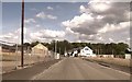
New housing development at Bishopton
Not yet on map
Image: © John Firth
Taken: 16 May 2014
0.18 miles
6
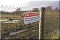
ROF Bishopton site
Fence beside the new housing development.
Image: © Richard Webb
Taken: 12 Dec 2015
0.19 miles
7
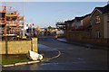
Building site, Bishopton
Some of the Royal Ordnance Factory site is being developed for housing.
Image: © Richard Webb
Taken: 12 Dec 2015
0.19 miles
8

Housing development, Bishopton
Part of the Royal Ordnance Factory site is being developed for housing.
Image: © Richard Webb
Taken: 12 Dec 2015
0.20 miles
9
Slateford Road
The ground works on the left are for the next lot of houses at the former ROF site. Slateford Road leads to a new roundabout at the A8 Greenock Road at Chestnut Avenue.
Image: © Thomas Nugent
Taken: 16 Apr 2018
0.20 miles
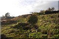
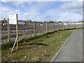
10
Bishopton
Some areas are still restricted at the former site of Royal Ordnance Factory at Bishopton. View through the fence showing some of the remaining buildings.
Image: © wfmillar
Taken: 30 Apr 2013
0.22 miles