IMAGES TAKEN NEAR TO
Montgomery Road, PAISLEY, PA3 4QJ
Introduction
This page details the photographs taken nearby to Montgomery Road, PA3 4QJ by members of the Geograph project.
The Geograph project started in 2005 with the aim of publishing, organising and preserving representative images for every square kilometre of Great Britain, Ireland and the Isle of Man.

There are currently over 7.5m images from over14,400 individuals and you can help contribute to the project by visiting https://www.geograph.org.uk
Image Map
Images are licensed for reuse under creativecommons.org/licenses/by-sa/2.0
Notes
- Clicking on the map will re-center to the selected point.
- The higher the marker number, the further away the image location is from the centre of the postcode.
Image Listing (51 Images Found)
Images are licensed for reuse under creativecommons.org/licenses/by-sa/2.0
Image
Details
Distance
1
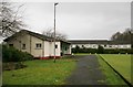
Gallowhill Bowling Green
A Renfrewshire Council facility.
Image: © Richard Sutcliffe
Taken: 17 Feb 2020
0.05 miles
2
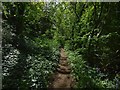
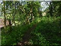
Path through the woods
See Image for a view in the opposite direction from about the same spot.
The path leads past, but not through, Image I interpret the path itself as following the line of a track that used to run past the western side of the house; see Image for further comments.
Image: © Lairich Rig
Taken: 19 May 2018
0.05 miles
3
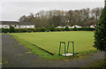
Gallowhill Bowling Green
A Renfrewshire Council facility.
Image: © Richard Sutcliffe
Taken: 17 Feb 2020
0.06 miles
4
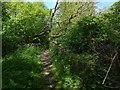
Path beside former site of Arkleston House
Arkleston House, now gone, was once known as West Arkleston. At the time of writing, North and South Arkleston survive as working farms, and East Arkleston as ruins: Image / Image / Image See Image for more on this area as a whole.
Note the section of wall just to the right (east) of the path in the present picture.
Image is just to the east, but the section of wall shown in the present picture is not part of the side-wall of the house itself. For one thing, this section of low wall has its top intact; it is clearly not a fragment of anything taller. But, more tellingly, it runs SSE—NNW (while the western wall of the house ran SSW—NNE).
This wall has the appearance of the boundary of a garden, and that is probably what it was: the 1939 revision of the OS map shows a track heading in this direction, just west of the former site of the house, and this wall probably served to separate that track from the garden of the house. The line of the track itself survives as the woodland path shown in the present picture (and in Image / Image).
Other low traces, no more than footings, survive nearby, crossing the line of the path in the area just behind the photographer.
Image: © Lairich Rig
Taken: 19 May 2018
0.06 miles
5
Path through the woods
See Image for a view in the opposite direction from about the same place. In the present picture, the building seen indistinctly in the left foreground is Montgomery Court (sheltered housing).
Directly ahead, at the foot of the slope, but partly hidden by the intervening trees, is a Image
Image: © Lairich Rig
Taken: 19 May 2018
0.06 miles
6
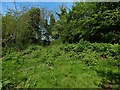
The former site of Arkleston House
The house, now gone, had earlier been known as West Arkleston. At the time of writing, North Arkleston and South Arkleston survive as working farms, and East Arkleston as ruins: Image / Image / Image
Although Arkleston House is gone, some traces remains, such as the wall (a little to the west of the house) shown in Image (it probably separated the house's garden from a track that ran beside it). Other low footings are visible nearby.
The site of the house itself is still evident, to an extent, as a clearing, the one in which the present picture was taken; the site has not yet become overgrown to the extent that it blends in with the surrounding woods.
Image: © Lairich Rig
Taken: 19 May 2018
0.07 miles
7
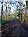
Path through the woods
The path is in an area of woodland that is bounded on the east by a Image, and on the west by the built-up Gallowhill area. A short Image from Arkleston Road meets up with this rougher track; see that item for further comments.
The place shown in the present picture was once the location of West Arkleston, which was later called Arkleston House; see Image and Image for more on that topic, and Image for more on the area as a whole.
Image: © Lairich Rig
Taken: 11 Jan 2014
0.07 miles
8
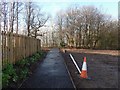
New path
The fence on the left is on the near side of the new house that can be seen in a picture of a Image (see Image for further comments).
At the time when the present picture was submitted, that house did not appear on OS mapping; instead, the map showed, in that area, a path leading diagonally away from the road.
The new path shown in this picture leads directly away from the road, as is shown in Image, a view in the opposite direction from the same point. It presumably replaces the former section of path that was obliterated by the building of the house, and it meets up with a rough Image that are visible in the background.
Image: © Lairich Rig
Taken: 11 Jan 2014
0.10 miles
9
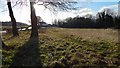
Grassy space beside Arkleston Road
This is a view over the area that is shown, viewed in the opposite direction, in Image See that item for further comments.
Image: © Lairich Rig
Taken: 11 Jan 2014
0.11 miles
10
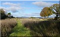
Grassy space beside Arkleston Road
The road itself is just to the right, bordered by the trees; a red car can be seen approaching a corner (compare Image, where the same trees are without leaves).
In the interval since an earlier picture was taken (Image), there has been some construction here; with respect to the present picture, the affected area is behind the photographer's position. For the same area, but viewed in the opposite direction, see Image
For the area just to the north (straight ahead, with respect to the present view), see Image
Image: © Lairich Rig
Taken: 4 Nov 2013
0.12 miles