IMAGES TAKEN NEAR TO
Dundonald Road, PAISLEY, PA3 4NA
Introduction
This page details the photographs taken nearby to Dundonald Road, PA3 4NA by members of the Geograph project.
The Geograph project started in 2005 with the aim of publishing, organising and preserving representative images for every square kilometre of Great Britain, Ireland and the Isle of Man.

There are currently over 7.5m images from over14,400 individuals and you can help contribute to the project by visiting https://www.geograph.org.uk
Image Map
Images are licensed for reuse under creativecommons.org/licenses/by-sa/2.0
Notes
- Clicking on the map will re-center to the selected point.
- The higher the marker number, the further away the image location is from the centre of the postcode.
Image Listing (16 Images Found)
Images are licensed for reuse under creativecommons.org/licenses/by-sa/2.0
Image
Details
Distance
1
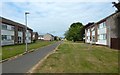
Kilwynet Way
At this end, the path meets Netherhill Road; the picture was taken from there.
Image: © Lairich Rig
Taken: 7 Jul 2018
0.07 miles
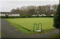
2
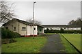
Gallowhill Bowling Green
A Renfrewshire Council facility.
Image: © Richard Sutcliffe
Taken: 17 Feb 2020
0.18 miles
3

Brewster Avenue
Priory Avenue leads off to the right. Image are in the right background.
Image: © Lairich Rig
Taken: 22 Sep 2018
0.19 miles
4
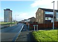
Montgomery Road
This is part of the Gallowhill area of Paisley. The path whose beginning is on the near right is Carron Way. In the left background is Image; out of shot to the left are the other two high flats, Image and Image
Image: © Lairich Rig
Taken: 11 Jan 2014
0.19 miles
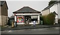
5
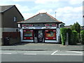
General grocer's shop
On Gallowhill Road, facing the railway line.
Image: © Thomas Nugent
Taken: 8 Jun 2008
0.20 miles
6
Gallowhill Bowling Green
A Renfrewshire Council facility.
Image: © Richard Sutcliffe
Taken: 17 Feb 2020
0.20 miles
7
Gallowhill Licensed Grocers
On Gallowhill Road.
Image: © Richard Sutcliffe
Taken: 17 Feb 2020
0.21 miles
8
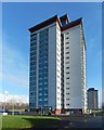
Gallowhill Court
The picture was taken from Image in the Gallowhill area of Paisley. Three high flats stand beside that road; from west to east, they are Gallowhill Court (shown here), Image, and Image
Image: © Lairich Rig
Taken: 11 Jan 2014
0.22 miles
9
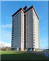
Arkleston Court
The picture was taken from Image in the Gallowhill area of Paisley. Three high flats stand beside that road; from west to east, they are Image, Image, and Arkleston Court (shown here).
Image and Image underwent refurbishment, but Arkleston Court was demolished later in 2014: Image / Image
Image: © Lairich Rig
Taken: 11 Jan 2014
0.22 miles
10
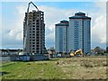
Arkleston Court: demolition in progress
A picture taken in January of the same year shows the building intact: Image
The other two high flats in the picture are Image (the nearer of the two) and Image All three buildings are on Image, in the Gallowhill area of Paisley. The photograph of the road also includes Arkleston Court in the background.
For another picture of the demolition, taken on the same day, but from a different location, see Image
The present view is from the roadside, on the boundary between Arkleston (to the east) and Gallowhill (to the west). For those areas and their names, see, respectively, Image and the last section of the description of Image
Image: © Lairich Rig
Taken: 3 Nov 2014
0.22 miles