IMAGES TAKEN NEAR TO
Linwood, PAISLEY, PA3 3AZ
Introduction
This page details the photographs taken nearby to PA3 3AZ by members of the Geograph project.
The Geograph project started in 2005 with the aim of publishing, organising and preserving representative images for every square kilometre of Great Britain, Ireland and the Isle of Man.

There are currently over 7.5m images from over14,400 individuals and you can help contribute to the project by visiting https://www.geograph.org.uk
Image Map
Images are licensed for reuse under creativecommons.org/licenses/by-sa/2.0
Notes
- Clicking on the map will re-center to the selected point.
- The higher the marker number, the further away the image location is from the centre of the postcode.
Image Listing (34 Images Found)
Images are licensed for reuse under creativecommons.org/licenses/by-sa/2.0
Image
Details
Distance
1
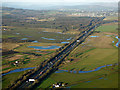
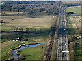
Farmland near Glasgow Airport from the air
Black Cart Water is in the foreground, the River Gryffe can be seen on the right. Bishopton is in the distance. The M8 motorway and the Glasgow to Gourock & Wemyss Bay railway line are prominent. Lots of standing water can be seen in the fields.
Image: © Thomas Nugent
Taken: 9 Dec 2019
0.03 miles
2
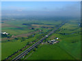
The M8 from the air
Black Cart Water can be seen passing under the motorway at Blackstoun Farm. The River Gryfe can be seen to the top right, just before it meets the Black Cart. The former Royal Ordnance Factory at Bishopton is hidden by the low cloud. The Glasgow to Gourock & Wemyss Bay railway line runs parallel to the motorway at this point.
Image: © Thomas Nugent
Taken: 12 Jun 2011
0.04 miles
3
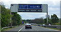
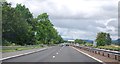
M8 gantry sign near Junction 29
This is the second westernmost of the Glasgow style 'CITRAC' (Centrally Intregated TRAffic Control) on the motorway. On approach to Junction 29 from the west.
Image: © Thomas Nugent
Taken: 5 May 2019
0.05 miles
5
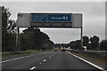
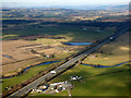
The M8 motorway from the air
Looking westbound, west of Junction 29. The Inverclyde Line railway to Gourock and Wemyss Bay runs alongside for around 1.5 miles. Black Cart Water is in the foreground.
Image: © Thomas Nugent
Taken: 6 Mar 2022
0.06 miles
7
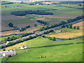
The M8 motorway from the air
At Blackstone Mains, where Black Cart Water passes under the road. The Glasgow to Gourock and Wemyss Bay railway line can also be seen, running parallel to the road.
Image: © Thomas Nugent
Taken: 30 Aug 2016
0.06 miles
8
Wester Walkinshaw Farm from the air
The M8 motorway and Black Cart Water can also be seen, with the River Gryffe also visible in the distance.
Image: © Thomas Nugent
Taken: 20 Mar 2016
0.07 miles
9
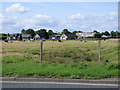
Wester Walkinshaw Farm
Viewed from the A726 Barnsford Road.
Image: © Thomas Nugent
Taken: 25 Aug 2018
0.08 miles
10
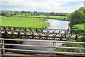
Footbridge and River at Blackstone Mains
Viewed from M8 eastbound
Image: © John Firth
Taken: 13 May 2011
0.08 miles