IMAGES TAKEN NEAR TO
Conval Way, PAISLEY, PA3 2QW
Introduction
This page details the photographs taken nearby to Conval Way, PA3 2QW by members of the Geograph project.
The Geograph project started in 2005 with the aim of publishing, organising and preserving representative images for every square kilometre of Great Britain, Ireland and the Isle of Man.

There are currently over 7.5m images from over14,400 individuals and you can help contribute to the project by visiting https://www.geograph.org.uk
Image Map
Images are licensed for reuse under creativecommons.org/licenses/by-sa/2.0
Notes
- Clicking on the map will re-center to the selected point.
- The higher the marker number, the further away the image location is from the centre of the postcode.
Image Listing (191 Images Found)
Images are licensed for reuse under creativecommons.org/licenses/by-sa/2.0
Image
Details
Distance
1
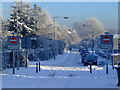
Marchfield Avenue
A traffic-calmed stretch of road which connects Marchfield Avenue to the new housing estate in Osprey Crescent acts as a fire path.
Image: © Thomas Nugent
Taken: 8 Dec 2010
0.06 miles
2
Fire path at Marchfield Road
Would a fire engine get through there?
Image: © Thomas Nugent
Taken: 17 Apr 2017
0.07 miles
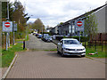
3
Fire path at Marchfield Avenue
The sign states that the path should be kept clear, an instruction which is often ignored. Osprey Road is in the background.
Image: © Thomas Nugent
Taken: 14 May 2018
0.07 miles
4
Fire path at Marchfield Avenue
The sign states that the path should be kept clear, an instruction which is often ignored. Osprey Road is in the background.
Image: © Thomas Nugent
Taken: 14 May 2018
0.07 miles
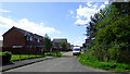
6

Travelodge at Glasgow Airport
Opposite the Courtyard by Marriott.
Image: © Thomas Nugent
Taken: 17 Apr 2017
0.09 miles
7

Travelodge at Glasgow Airport
Opposite the Courtyard by Marriott.
Image: © Thomas Nugent
Taken: 17 Apr 2017
0.09 miles
9
Albany Way
Albany Way is on the right, Birkenshaw Way is on the left.
Image: © Thomas Nugent
Taken: 25 Sep 2017
0.09 miles
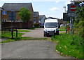
10
Osprey Crescent
At Osprey Road/Gockston Road.
Image: © Thomas Nugent
Taken: 17 Apr 2017
0.10 miles