IMAGES TAKEN NEAR TO
Darkwood Drive, PAISLEY, PA3 1TA
Introduction
This page details the photographs taken nearby to Darkwood Drive, PA3 1TA by members of the Geograph project.
The Geograph project started in 2005 with the aim of publishing, organising and preserving representative images for every square kilometre of Great Britain, Ireland and the Isle of Man.

There are currently over 7.5m images from over14,400 individuals and you can help contribute to the project by visiting https://www.geograph.org.uk
Image Map
Images are licensed for reuse under creativecommons.org/licenses/by-sa/2.0
Notes
- Clicking on the map will re-center to the selected point.
- The higher the marker number, the further away the image location is from the centre of the postcode.
Image Listing (69 Images Found)
Images are licensed for reuse under creativecommons.org/licenses/by-sa/2.0
Image
Details
Distance
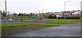
1
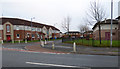
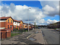
Darkwood Drive
Off Ferguslie Park Avenue.
Image: © Thomas Nugent
Taken: 20 Nov 2016
0.02 miles
2
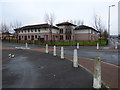
Darkwood Court
A Sheltered housing complex http://www.housingcare.org/housing-care/facility-info-86900-darkwood-court-ferguslie-park-scotland.aspx off Ferguslie Park Avenue.
Image: © Thomas Nugent
Taken: 20 Nov 2016
0.03 miles
3
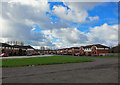
Ferguslie Park Avenue
'Ferguslie Park has improved over many years by building centres for sports and leisure for all ages. However, in 2012 the "Scottish Index of Multiple Deprivation" analysis by the Scottish Government again identified Ferguslie Park as the most deprived area in Scotland.' (Source - Wikipedia).
The regeneration of the estate continues. Here, smart, modern housing stands in Ferguslie Park Avenue.
Image: © Richard Dorrell
Taken: 2 Apr 2019
0.03 miles
4
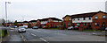
Ferguslie Park Avenue
Near the junction with Darkwood Drive.
Image: © Thomas Nugent
Taken: 20 Nov 2016
0.04 miles
5
Ferguslie Park Avenue
Modern housing on the western edge of the estate.
Image: © Richard Dorrell
Taken: 2 Apr 2019
0.05 miles
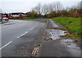
6
Ferguslie Park Avenue
Evidence of fly-tipping can be seen.
Image: © Thomas Nugent
Taken: 20 Nov 2016
0.07 miles
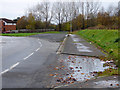
7
Ferguslie Park Avenue
The road curves to the left at this point, possibly re-aligned when the old houses were demolished.
Image: © Thomas Nugent
Taken: 20 Nov 2016
0.07 miles
8
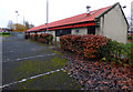
Falcon Day Centre
On Falcon Crescent. Renfrewshire Council's web site http://www.renfrewshire.gov.uk/article/4225/Falcon-Day-Centre describes the centre as follows, "Falcon Day Centre provides day care to older people who have been assessed as requiring a service to help them remain in their community and be as independent as possible. The centre caters for older people who have a diagnosis of dementia, or who have a reduced physical capacity."
Image: © Thomas Nugent
Taken: 20 Nov 2016
0.07 miles
9
Playground at Darkwood Drive
Ferguslie Park, Paisley.
Image: © Thomas Nugent
Taken: 20 Nov 2016
0.08 miles
10
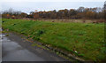
Ferguslie Park undergrowth
The distant trees mark the line of the disused Paisley and Barrhead District Railway line (known locally as the Dummy Line) http://railway.paisleyhistory.uk/pbdr.html . It was used as recently as the 1980s as a spur for the car factory at Linwood which closed at that time. Prior to the car factory, it also served as a spur for the Pressed Steel factory at Linwood which produced the "blue trains" (Class 303), which were the first electric trains for the north and south Clyde lines in the 1960s.
The embankment in the foreground is to prevent access to the waste ground by unauthorised vehicles.
Image: © Thomas Nugent
Taken: 20 Nov 2016
0.09 miles