IMAGES TAKEN NEAR TO
Caplethill Road, PAISLEY, PA2 7TR
Introduction
This page details the photographs taken nearby to Caplethill Road, PA2 7TR by members of the Geograph project.
The Geograph project started in 2005 with the aim of publishing, organising and preserving representative images for every square kilometre of Great Britain, Ireland and the Isle of Man.

There are currently over 7.5m images from over14,400 individuals and you can help contribute to the project by visiting https://www.geograph.org.uk
Image Map
Images are licensed for reuse under creativecommons.org/licenses/by-sa/2.0
Notes
- Clicking on the map will re-center to the selected point.
- The higher the marker number, the further away the image location is from the centre of the postcode.
Image Listing (23 Images Found)
Images are licensed for reuse under creativecommons.org/licenses/by-sa/2.0
Image
Details
Distance
1
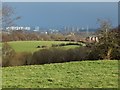
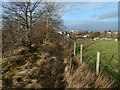
Field at Stoney Brae
The picture was taken from the edge of the field (Image), just off a path called Stoney Brae; see http://www.geograph.org.uk/snippet/12792 for that path.
A house called Image can be seen in the middle distance, on the right.
Much further away, a little right of centre, is the distinctive water tower of the former Leverndale Hospital, 3.4 km away: Image / Image / Image
Image: © Lairich Rig
Taken: 26 Jan 2015
0.12 miles
2
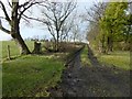
Stoney Brae
This is a view in the opposite direction (uphill) along the section of track shown in Image The top of a building can be seen in the left background: Image
Image: © Lairich Rig
Taken: 26 Jan 2015
0.12 miles
3
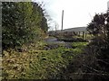
Stoney Brae
This is a continuation of the path shown in Image The present picture was taken from 150 metres further along the path; at this point, the path meets a farm track, and the route (which is called Stoney Brae) continues along the track.
Image: © Lairich Rig
Taken: 26 Jan 2015
0.13 miles
4
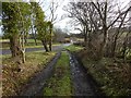
Stoney Brae
This is the last part of the downhill route; it ends where it meets Caplethill Road, a small part of which can be seen ahead, behind a white sign. The nearer road heading off to the left leads to a sports centre.
Image: © Lairich Rig
Taken: 26 Jan 2015
0.14 miles
5
Edge of field at Stoney Brae
For the field, see Image The present picture was taken from beside Stoney Brae (the path of that name – see http://www.geograph.org.uk/snippet/12792 for pictures); the path is on the other side of the line of trees on the left.
The nearest rooftops on the right are those of houses on Braefoot Crescent.
Image: © Lairich Rig
Taken: 26 Jan 2015
0.14 miles
6
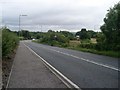
Approaching bend on Caplethill Road
Near the Thornly Park Campus of the University of the West of Scotland.
Image: © Stephen Sweeney
Taken: 12 Aug 2009
0.15 miles
7
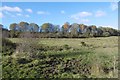
Pasture outside Paisley
The line of trees is on the trackbed of the Glasgow and Southwest Railway's Barrhead Branch.
Image: © Richard Webb
Taken: 6 Nov 2016
0.15 miles
8
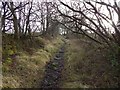
Stoney Brae
The path, which was formerly a road, is marked on the 1:25000 map. Followed in this direction, it leads to Caplethill Road.
Image: © Lairich Rig
Taken: 26 Jan 2015
0.15 miles
9
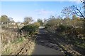
Bike path, Paisley
Off Caplethill Road.
Image: © Richard Webb
Taken: 6 Nov 2016
0.16 miles
10
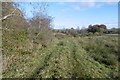
A grassy track outside Paisley
Marked as a path on the 1:50,000 map the track crosses damp pasture.
Image: © Richard Webb
Taken: 6 Nov 2016
0.18 miles