IMAGES TAKEN NEAR TO
Dixon Avenue, DUNOON, PA23 8NA
Introduction
This page details the photographs taken nearby to Dixon Avenue, PA23 8NA by members of the Geograph project.
The Geograph project started in 2005 with the aim of publishing, organising and preserving representative images for every square kilometre of Great Britain, Ireland and the Isle of Man.

There are currently over 7.5m images from over14,400 individuals and you can help contribute to the project by visiting https://www.geograph.org.uk
Image Map (Loading...)


Getting Data...Please wait
Leaflet Map data © OpenStreetMap
Images are licensed for reuse under creativecommons.org/licenses/by-sa/2.0
Notes
- Clicking on the map will re-center to the selected point.
- The higher the marker number, the further away the image location is from the centre of the postcode.
Image Listing (43 Images Found)
Images are licensed for reuse under creativecommons.org/licenses/by-sa/2.0
Image
Details
Distance
1
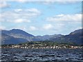
North Dunoon and Kirn
Viewed from across the Clyde at Inverkip.
Image: © Thomas Nugent
Taken: 30 May 2006
0.05 miles
2
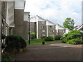
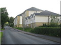
Fairhaven at Kirn
A view of one of the 'courtyard' areas. An interesting housing development, seen here from Ardenslate Road. Built, I have been told, in the 1960s for the American forces based at Holy Loch, but I have been unable to find any details. There are 10 V-shaped blocks, each of about 9-10 interlocking flats and maisonettes, in a pleasant landscaped garden setting. As a housing development it is far more attractive than the standard UK 1960s housing blocks.
Image: © M J Richardson
Taken: 2 Jun 2017
0.10 miles
3
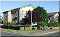
Fairhaven at Kirn
An interesting housing development, seen here from Ardenslate Road. Built, I have been told, in the 1960s for the American forces based at Holy Loch, but I have been unable to find any details. There are 10 V-shaped blocks, each of about 9-10 interlocking flats and maisonettes, in a pleasant landscaped garden setting. As a housing development it is far more attractive than the standard UK 1960s housing blocks.
Image: © M J Richardson
Taken: 4 Jun 2017
0.11 miles
4
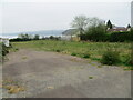
The site of the recently demolished Kirn United Presbytarian Church
Looking south-eastward. Storm damage to the church has resulted in its demise. No doubt now a prime site for housing.
Image: © Peter Wood
Taken: 4 May 2024
0.12 miles
5
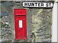
Victoria Regina post box, Hunter Street, Kirn
Image: © John Ferguson
Taken: 12 Apr 2020
0.14 miles
7
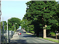
Ardenslate Road
Looking towards Kirn.
Image: © Thomas Nugent
Taken: 10 Aug 2012
0.15 miles
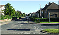
8
Ardenslate Road
A building site by Cowal Golf Club.
Image: © Thomas Nugent
Taken: 10 Aug 2012
0.15 miles
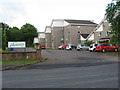
9
Houses on Ardenslate Road
Looking west at Kirn, on the outskirts of Dunoon.
Image: © M J Richardson
Taken: 4 Jun 2017
0.15 miles
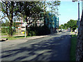
10
Ardenslate Road
Argyll Road is to the right of the photo.
Image: © Thomas Nugent
Taken: 10 Aug 2012
0.15 miles