IMAGES TAKEN NEAR TO
Campbell Street, GREENOCK, PA16 8AN
Introduction
This page details the photographs taken nearby to Campbell Street, PA16 8AN by members of the Geograph project.
The Geograph project started in 2005 with the aim of publishing, organising and preserving representative images for every square kilometre of Great Britain, Ireland and the Isle of Man.

There are currently over 7.5m images from over14,400 individuals and you can help contribute to the project by visiting https://www.geograph.org.uk
Image Map
Images are licensed for reuse under creativecommons.org/licenses/by-sa/2.0
Notes
- Clicking on the map will re-center to the selected point.
- The higher the marker number, the further away the image location is from the centre of the postcode.
Image Listing (256 Images Found)
Images are licensed for reuse under creativecommons.org/licenses/by-sa/2.0
Image
Details
Distance
1
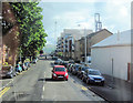
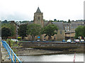
Campbell Street from Brougham street
Viewed towards the shore. McMillan Motors is the white building on the right
Image: © John Firth
Taken: 13 May 2011
0.02 miles
2

Old corbel stone
The stone, dated 1625, is built into the north-western wall of the kirkyard of Image It is almost as old as the first Old West Kirk building, which stood nearby (see the last-cited link); the stone dates from only about 34 years later.
The wall also includes the oldest surviving gravestones from the original kirkyard: Image and Image
Image: © Lairich Rig
Taken: 4 Jul 2011
0.03 miles
3

The gravestone of Alexander Knox
The stone is Image; see that item for context, and for why the picture is a side-on view. For more details about the kirk itself, see Image
The lighter stone on the right says only: "In Memory of / Alexander Knox / Crawfordsdyke / Born 1722 / Died 1774". However, the darker stone is the one in which I was mainly interested. It has a Latin inscription (the only one in the kirkyard), which says:
"1769 / Hoc / Est Solum Sepulchrale / Alexandri Knox / Cerͤvisiarii in Vico / Crawfordsdyke / Patet / In longitudinem Octo / In latitudinem totidem / Hoc est / Sexaginta quatuor / quadratos Pedes".
There is a raised "E" over one word: "CERͤVISIARII" (elsewhere, that Latin word is sometimes spelled with the "e", and sometimes without). Because the gravestones have, like the church itself, been relocated, the inscription appears to describe a tomb that is no longer there; in my translation: "This alone is the sepulchre of Alexander Knox, brewer in the village of Crawfordsdyke. It extends eight (feet) in length, and exactly as many in width, in other words, sixty-four square feet."
[For another view of the stone, see David W. Edgar's page – http://www.lylekirk.org/owk%20web2/Page7.html – on the kirkyard. That page has photographs of many more old gravestones than I have submitted, and gives their inscriptions; it also interprets the symbols that appear on some of them.]
The stone identifies Knox as a brewer or maltman ("cervisiarius" or "cerevisiarius", a non-Classical word: compare the equivalent Spanish word "cerverzero", for a beer brewer, and "cerveza"). His brewery was in the village of Crawfordsdyke; that area, now called Cartsdyke, has been subsumed by Greenock, of which it is presently a suburb. The inscription places emphasis on the dimensions of the plot that was associated with this gravestone.
In his book "Old Greenock" (1888), George Williamson writes that "Mr Knox was one of the proprietors of the brewery. He was survived by his wife, Mary Allason, and his son Alexander, who acquired part of the property on which the brewery stood. The son's tablet, with an English inscription, adjoins his father's, but it is rapidly becoming undecipherable through decay".
[It should be borne in mind that, as noted above, the stones (and the church as a whole) have been moved since those words were written. Nevertheless, the lighter tablet on the right does appear to commemorate Alexander's son of the same name; perhaps it is a replacement for the badly decayed stone mentioned in the quotation.]
The brewery passed into the ownership of James Watt (not the well-known engineer of that name), who acquired it from Knox's widow. James Watt was succeeded by his nephew William. As Archibald Brown writes in "The Early Annals of Greenock" (1905), William "assumed as partner a Mr. Gourley from Glasgow, but in course of time they came to grief. The premises were then occupied in turn as a sugar refinery, meal mill and bakery, and afterwards as a soap work, but none of these enterprises succeeded. The property was in the market for sale for several years, and ultimately it was bought by the late Mr. James McLean, who afterwards sold it to the Harbour Trust for a large sum of money".
Image: © Lairich Rig
Taken: 4 Jul 2011
0.04 miles
4
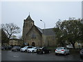
Greenock, Old West Kirk
A reconstruction of the original church which stood on a site developed by Harland and Wolff for shipbuilding. This was undertaken under the supervision of James Miller in 1925 - 8 https://www.britishlistedbuildings.co.uk/200406625-lyle-kirk-esplanade-building-former-old-west-kirk-campbell-street-greenock-greenock#.Wha5AjdpHVI
Image: © Jonathan Thacker
Taken: 31 Oct 2017
0.04 miles
5
The Old West Kirk
The picture was taken from Campbell Street. Image is at the extreme right. For another view of the church, see Image For the inscription on the near side of the building, see Image
As is noted on that inscription, a kirk was built in Greenock by Sir John Schaw / Shaw in 1591 (the kirk that now stands here is clearly much more recent, but it incorporates parts of the earlier Old West Kirks).
It was in 1589 that a royal charter by James VI granted Shaw permission to separate a portion from the parish of Inverkip in order to form the parish of Greenock; it also granted him permission "on his awin coist to Erect and big one parroche kirk vpoun his awin heretage"; the kirk was to be for the benefit of the poor people of "Grenok fynnartie and spangok" (Greenock, Finnart, and Spango), specifically, for "the puir pepill duelling vpoun his lands and heretage qlkis ar all fischers and of a ressounable nowmer duelland four myles fra thair parroche kirk" ["qlkis": quhilkis = which; "duelland": dwelling].
[The charter describes the poor who were living on Shaw's lands and heritage as fishers (there were then small fishing communities in what is now Greenock). They were said to be living four miles from their parish kirk, i.e., the existing one, at Inverkip.]
This charter was ratified by the Scottish Parliament in 1592. For those who are comfortable with the language (Middle Scots), much of the text of the charter (which also describes the difficulties the poor of Greenock faced in reaching the parish kirk at Inverkip, especially in winter) is reproduced in Daniel Weir's "History of the Town of Greenock" (1829).
The church and manse were finished in 1591, and there was an adjoining kirkyard by 1592; this first Old West Kirk was at a different site: Image / Image
Writing in the early nineteenth century, Weir notes that the church had largely been rebuilt about 70 years earlier, and that "the oldest gravestone bears the date 1675". Gravestones with that date can still be seen beside the present-day church building (see Image), where they have been incorporated into the north-western wall of the kirkyard: Image and Image A corbel stone bearing the date 1625 has also been built into that wall: Image
[For a feature, probably from the mid-eighteenth century, that is built into the wall of the church building itself, see Image]
After Weir's time, there were to be further changes. By the 1830s, the church had been in use for over two centuries, and was in very poor condition. As Robert Murray Smith notes in his "History of Greenock" (1921), "the kirk was said then to be most uncomfortable and unhealthy. The churchyard was so filled up that the earth outside was two feet above the level of the floor, and in rainy weather it was necessary to place boards to enable the people to step in at the doors". He adds that, as it was expressed at the time, the congregation were "just sitting over a pool of liquid mud".
That building was condemned in 1837, and a move was made to a church on a new site in 1841. However, the church on the original site was rebuilt in 1864, and it was this building that was later moved in its entirety: in 1926, it was rebuilt in its present location, using as much of the material of the 1864 building as was practical. The building that was finished in 1926 is the present-day Old West Kirk, the one that is shown in this photograph. See http://portal.historic-scotland.gov.uk/designation/LB34095 (at Historic Environment Scotland) for its listed building report, which expands upon some of these details.
A few of the memorials were moved along with the church; others were relocated to a site within Greenock Cemetery: Image
Image: © Lairich Rig
Taken: 4 Jul 2011
0.04 miles
6
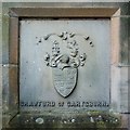
Coat of arms of Crawfurd of Cartsburn
This feature appears at the base of the north-eastern wall of Image As is described in that item in some detail, the church has been much altered (and has even been moved in its entirety) since John Schaw had the original Old West Kirk built in 1591.
In 1829, Daniel Weir recorded in his work "The History of Greenock" that, even then, "the church as now seen is different from what it was at its first erection, and had not the wings containing Sir Michael S. Stewart's and Cartsburn's seat till about 70 years ago, when it was mostly rebuilt".
Cartsburn's arms, shown here, were presumably installed during that particular rebuilding; his crest includes, on the left, a sword with balances perched on its point. Above it, the motto on the left is "quod tibi, hoc alteri" ("what to you, this to other", i.e., "do to others as you would have them do to you"). On the right, it reads "nil durum volenti" ("nothing is hard for the willing").
Image: © Lairich Rig
Taken: 4 Jul 2011
0.04 miles
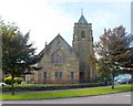
7
The Old West Kirk
A Category A Listed church building http://portal.historicenvironment.scot/designation/LB34095 at the east end of Greenock Esplade. This building was successor to the original 1591 building which was the first Presbyterian church to be built in Scotland after the Reformation and enabled the people of Greenock to worship locally. Their nearest church was previously at Inverkip, about 5 miles away as the crow flies.
The Historic Environment Scotland Listing http://portal.historicenvironment.scot/designation/LB34095 is worth reading as it provides much detail about the building and its history.
Image: © Thomas Nugent
Taken: 6 Aug 2017
0.04 miles
8
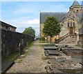
Behind the Old West Kirk
Image itself is in the background, on the right. In the foreground, on the right, are various recumbent slabs; to their right is the Pirrie Hall, only a small part of which is visible.
The wall at the left-hand side of the photograph incorporates a number of old gravestones; the oldest of them, Image and the Image, date from 1675. The wall also incorporates an Image dated 1625.
The Old West Kirk was moved, brick-by-brick, to its present location in 1926-28. Some of the memorials beside the church were moved along with it, and many of them are visible in this photograph.
However, many others were moved to a new location, in a plot within Greenock Cemetery: Image
Behind and to the left of the tree that is near the centre of the photo, a white panel can be seen on the church wall. To its left is a dark panel, although, from this angle, it is largely hidden by a bush. The latter is Image, a brewer.
Image: © Lairich Rig
Taken: 4 Jul 2011
0.04 miles
9
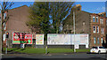
Advertising hoardings, Greenock
In an open corner between tenements at Campbell Street and Eldon Street.
Image: © Thomas Nugent
Taken: 16 Apr 2024
0.05 miles
10

The gravestone of John Taylor
Writing in 1829, Daniel Weir noted that the oldest stone to be seen in the graveyard of Image was dated 1675. There are a couple of stones from that year; my photograph shows one of them, dating from August. For the other 1675 stone, dating from May of that year, see below. My particular interest in those stones is that they are the oldest.
The church has been moved since Weir's day, but a few old gravestones, like this one, have been preserved by being incorporated in the north-western wall of the kirkyard (for context, see Image). The same wall also includes a corbel stone which is dated 1625: Image
The inscription reads as follows: "This is the place appoynted for the burial of Iohn Tylor his wyfe and children / 3 Agust 1675 / IT / AH".
Those last initials are those of Taylor and his wife. The elaborate glyphs between the initials resemble a mason's mark, but they are probably what is called "a merchant's 4". The other stone that is dated 1675 is next to this one (it is out of shot to the left), and bears a mark that is not identical, but which is very similar: Image
Also to be seen nearby is the gravestone for a later Alexander Taylor (so spelled on the inscription), a weaver, who died in 1758. For a link to a site that shows many more of the old stones, and which gives their inscriptions, see Image
Image: © Lairich Rig
Taken: 4 Jul 2011
0.05 miles