IMAGES TAKEN NEAR TO
Woodlark Grove, GREENOCK, PA16 0LZ
Introduction
This page details the photographs taken nearby to Woodlark Grove, PA16 0LZ by members of the Geograph project.
The Geograph project started in 2005 with the aim of publishing, organising and preserving representative images for every square kilometre of Great Britain, Ireland and the Isle of Man.

There are currently over 7.5m images from over14,400 individuals and you can help contribute to the project by visiting https://www.geograph.org.uk
Image Map
Images are licensed for reuse under creativecommons.org/licenses/by-sa/2.0
Notes
- Clicking on the map will re-center to the selected point.
- The higher the marker number, the further away the image location is from the centre of the postcode.
Image Listing (74 Images Found)
Images are licensed for reuse under creativecommons.org/licenses/by-sa/2.0
Image
Details
Distance
1
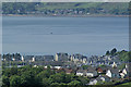
Kip Marina Village from the Greenock Cut
The housing estate at the top of Swallow Brae is in the foreground. The north end of Innellan is in the distance.
See my geograph article for detail of the cut http://www.geograph.org.uk/article/The-Greenock-Cut .
Image: © Thomas Nugent
Taken: 2 Jun 2013
0.02 miles
2
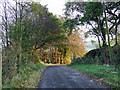
Millhouse Road
Leads to Shielhill Glen and Loch Thom from Inverkip village. The Glasgow to Wemyss Bay railway line runs in a cutting just beyond the fence on the left.
Image: © Thomas Nugent
Taken: 7 Nov 2007
0.04 miles
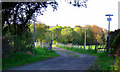
3
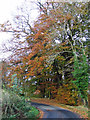
Millhouse Road
Looking towards Inverkip from the junction with the track to Idzholm.
Image: © Thomas Nugent
Taken: 7 Nov 2007
0.05 miles
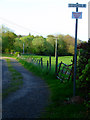
5
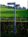
New sign on Millhouse Road
One of many new similar type signs which have appeared in the area recently
Image: © Thomas Nugent
Taken: 26 Apr 2011
0.07 miles
6
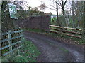
Railway bridge near Idzholm
On the farm track to Idzholm Image The warning sign on the left used to be red!
Image: © Thomas Nugent
Taken: 7 Nov 2007
0.07 miles
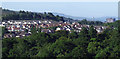
7
Inverkip and the Firth of Clyde
The Swallow Brae housing estate viewed from Langhill. Ardgowan Policies, Dunoon and the south Highlands are in the distance.
Image: © Thomas Nugent
Taken: 11 Apr 2020
0.07 miles
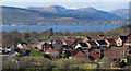
8
Swallow Brae
Swallow Brae housing estate, Inverkip, with Inverclyde Royal Hospital in the distance. Viewed from the park at Cullen Crescent.
Image: © Thomas Nugent
Taken: 9 Jul 2013
0.07 miles
9
Lane leading to Eidsholm
Off Millhouse Road. The "Private" sign is a fairly recent addition.
Image: © Thomas Nugent
Taken: 26 Apr 2011
0.08 miles
10
Lane leading to Eidsholm
Complete with new "Private" signs. The lane leads off Millhouse Road, near Brueacre boarding kennels.
Image: © Thomas Nugent
Taken: 26 Apr 2011
0.08 miles