IMAGES TAKEN NEAR TO
Main Street, GREENOCK, PA16 0AU
Introduction
This page details the photographs taken nearby to Main Street, PA16 0AU by members of the Geograph project.
The Geograph project started in 2005 with the aim of publishing, organising and preserving representative images for every square kilometre of Great Britain, Ireland and the Isle of Man.

There are currently over 7.5m images from over14,400 individuals and you can help contribute to the project by visiting https://www.geograph.org.uk
Image Map
Images are licensed for reuse under creativecommons.org/licenses/by-sa/2.0
Notes
- Clicking on the map will re-center to the selected point.
- The higher the marker number, the further away the image location is from the centre of the postcode.
Image Listing (737 Images Found)
Images are licensed for reuse under creativecommons.org/licenses/by-sa/2.0
Image
Details
Distance
1
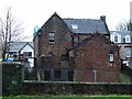
Former Inverkip Police Station
The rear of the building, viewed from the path by the A78 road. Planning permission to convert the building to a restaurant was recently refused.
Image: © Thomas Nugent
Taken: 3 Jan 2012
0.02 miles
2
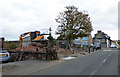
Site of Inverkip Police station
The police station was demolished in October 2019. It was last used as a police station in 2002. This is the rear of the property, viewed across the A78 road.
See the same scene in January 2012 Image
Image: © Thomas Nugent
Taken: 18 Mar 2020
0.02 miles
4
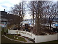
Kip Marina Boatyard
View of part of the Kip marina boat yard taken from the footbridge over the A78. What appears to be an old cable laying craft can be seen amongst the trees and the ubiquitous power station chimney can be seen peeping over the hill on the left. The sign on the wall refers to a housing development on the banks of the marina.
Image: © Thomas Nugent
Taken: 22 Mar 2006
0.02 miles
5
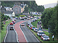
The A78 at Inverkip
Motorists eager to view the demolition of Inverkip Power Station chimney parked just about anywhere they liked, including access roads, footpaths and grass verges.
Image: © Thomas Nugent
Taken: 28 Jul 2013
0.02 miles
6
Inverkip police station demolition
Emergency demolition due to safety concerns about the structure of the building. The building on Main Street was vacated by the police in 2002 at which time it was converted to flats. It was subject to a failed planning application to convert it to a Chinese restaurant in 2011.
A new police station was opened at the Kip Park development at the north end of Main Street around 2007.
Image: © Thomas Nugent
Taken: 21 Oct 2019
0.02 miles
7
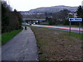
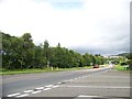
National Cycle Route at Inverkip
A short section of Route 753 by the A78 at Kip Marina was constructed in March 2011. It will eventually connect to the route at Lunderston Bay by means of an improved path along the shore at Ardgowan Estate.
Image: © Thomas Nugent
Taken: 6 Apr 2011
0.02 miles

9
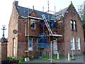
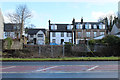
Former Inverkip Police Station
The building on Main Street was vacated by the police in 2002 at which time it was converted to flats. It was subject to a failed planning application to convert it to a Chinese restaurant in 2011.
A new police station was opened at the Kip Park development at the north end of Main Street around 2007.
Image: © Thomas Nugent
Taken: 29 Jun 2011
0.02 miles
10
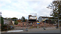
Inverkip police station demolition
Emergency demolition due to safety concerns about the structure of the building. The building on Main Street was vacated by the police in 2002 at which time it was converted to flats. It was subject to a failed planning application to convert it to a Chinese restaurant in 2011.
A new police station was opened at the Kip Park development at the north end of Main Street around 2007.
Image: © Thomas Nugent
Taken: 21 Oct 2019
0.02 miles