IMAGES TAKEN NEAR TO
Lynedoch Street, GREENOCK, PA15 4BG
Introduction
This page details the photographs taken nearby to Lynedoch Street, PA15 4BG by members of the Geograph project.
The Geograph project started in 2005 with the aim of publishing, organising and preserving representative images for every square kilometre of Great Britain, Ireland and the Isle of Man.

There are currently over 7.5m images from over14,400 individuals and you can help contribute to the project by visiting https://www.geograph.org.uk
Image Map
Images are licensed for reuse under creativecommons.org/licenses/by-sa/2.0
Notes
- Clicking on the map will re-center to the selected point.
- The higher the marker number, the further away the image location is from the centre of the postcode.
Image Listing (154 Images Found)
Images are licensed for reuse under creativecommons.org/licenses/by-sa/2.0
Image
Details
Distance
1
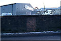
Lynedoch Street
The bridge carries the Glasgow to Wemyss Bay railway line. The bricked-up archway on the left led to the former Upper Greenock station which closed in 1967.
Image: © Thomas Nugent
Taken: 27 Jan 2015
0.10 miles
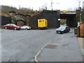
2
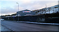
Drumfrochar Industrial Estate
Home to several motor vehicle related business.
Image: © Thomas Nugent
Taken: 4 Dec 2012
0.11 miles
3
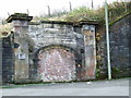
Former Upper Greenock railway station entrance
The bricked up entrance to the former Upper Greenock station on Upper Lynedoch Street.
Image: © Thomas Nugent
Taken: 9 Nov 2007
0.11 miles
4
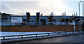
M & J builders yard
At the corner of Lynedoch Street and Drumfrochar Road. The yard was previously located at Union Street Image
Image: © Thomas Nugent
Taken: 4 Dec 2012
0.11 miles
5
M & J builders yard
An old doorway in the wall on the Drumfrochar Road side of the yard.
Image: © Thomas Nugent
Taken: 4 Dec 2012
0.11 miles
6
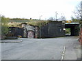
Site of Upper Greenock railway station
Upper Greenock Station was on the Wemyss Bay line at Upper Lynedoch Street. The only remaining trace is this bricked up entrance. The bridge to the right carries the Wemyss Bay line.
Image: © Thomas Nugent
Taken: 9 Nov 2007
0.12 miles
7
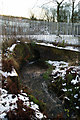
Water channel at Drumfrochar Place
This short stretch of fast flowing water is a long disused off-shoot of the Greenock Cut system http://www.geograph.org.uk/article/The-Greenock-Cut . Another section can be seen nearby at Drumfrochar Road Image
Image: © Thomas Nugent
Taken: 4 Dec 2012
0.12 miles
8
Drumfrochar Road
An old wall near the Mearns Street junction.
Image: © Thomas Nugent
Taken: 4 Dec 2012
0.12 miles
9
Drumfrochar Road
The M & J builders yard at the corner of Lynedoch Street.
Image: © Thomas Nugent
Taken: 4 Dec 2012
0.12 miles
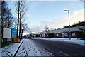
10
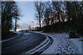
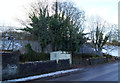
Drumfrochar Place
Leads from Drumfrochar Road to Drumfrochar Industrial Estate.
Image: © Thomas Nugent
Taken: 4 Dec 2012
0.13 miles