IMAGES TAKEN NEAR TO
Gibson Street, GREENOCK, PA15 2NT
Introduction
This page details the photographs taken nearby to Gibson Street, PA15 2NT by members of the Geograph project.
The Geograph project started in 2005 with the aim of publishing, organising and preserving representative images for every square kilometre of Great Britain, Ireland and the Isle of Man.

There are currently over 7.5m images from over14,400 individuals and you can help contribute to the project by visiting https://www.geograph.org.uk
Image Map (Loading...)


Getting Data...Please wait
Leaflet Map data © OpenStreetMap
Images are licensed for reuse under creativecommons.org/licenses/by-sa/2.0
Notes
- Clicking on the map will re-center to the selected point.
- The higher the marker number, the further away the image location is from the centre of the postcode.
Image Listing (87 Images Found)
Images are licensed for reuse under creativecommons.org/licenses/by-sa/2.0
Image
Details
Distance
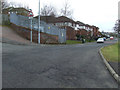
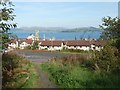
2
Bell Street, Gibshill
The estate is on the fringes of the built-up area. It is shown from above (from the cycle path) in Image
Image: © Lairich Rig
Taken: 3 Oct 2016
0.03 miles
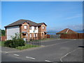
4
Irwin Street
Viewed from Shankland Road.
Image: © Thomas Nugent
Taken: 16 Mar 2013
0.08 miles
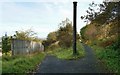
5
The lower end of a path to Gibshill
This is the lower end of a Image Here, at its lower end, the path enters the Gibshill housing estate beside the junction of Poplar Street and Cobham Street.
Image: © Lairich Rig
Taken: 3 Oct 2016
0.09 miles
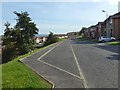
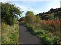
6
Path leaving the cycle route above Gibshill
The cycle route here (shown on the right) is at the upper margin of the Image housing estate; the short path shown heading downhill on the left leads there. For a view from its lower end, see Image
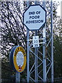
The junction shown in the present picture, and marked by what looks like an industrial relic, is shown from the other side in Image
The upright pipe may be intended as artwork, given that there are industrial-themed sculptures nearby on this cycle path: Image / Image
Image: © Lairich Rig
Taken: 3 Oct 2016
0.09 miles
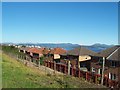
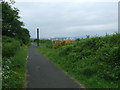
7
Cycle path above Gibshill
For a view in the opposite direction from about 30 metres ahead, see Image The present view shows the slopes of Knocknairs Hill on the right.
Image: © Lairich Rig
Taken: 3 Oct 2016
0.09 miles
8
National Cycle Route 75
On the former Princes Pier railway line at Gibshill.
Image: © Thomas Nugent
Taken: 5 Jun 2008
0.09 miles
9
Signs
On the Glasgow bound platform at Bogston station.
Image: © Thomas Nugent
Taken: 23 Nov 2007
0.10 miles
10
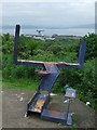
Cycle path sculpture
An artist's easel and paintbrush on a steel girder frame. James Watt Dock is visible through the frame.
Image: © Thomas Nugent
Taken: 5 Jun 2008
0.11 miles