IMAGES TAKEN NEAR TO
East Road, PORT GLASGOW, PA14 5TD
Introduction
This page details the photographs taken nearby to East Road, PA14 5TD by members of the Geograph project.
The Geograph project started in 2005 with the aim of publishing, organising and preserving representative images for every square kilometre of Great Britain, Ireland and the Isle of Man.

There are currently over 7.5m images from over14,400 individuals and you can help contribute to the project by visiting https://www.geograph.org.uk
Image Map
Images are licensed for reuse under creativecommons.org/licenses/by-sa/2.0
Notes
- Clicking on the map will re-center to the selected point.
- The higher the marker number, the further away the image location is from the centre of the postcode.
Image Listing (101 Images Found)
Images are licensed for reuse under creativecommons.org/licenses/by-sa/2.0
Image
Details
Distance
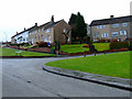
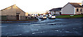
1
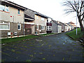
Bridgend Avenue
Houses on the north side of the road.
Image: © Thomas Nugent
Taken: 13 Dec 2013
0.09 miles
2
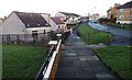
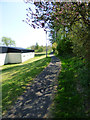
Bridgend Avenue
The path on the north side of the road.
Image: © Thomas Nugent
Taken: 13 Dec 2013
0.10 miles
3
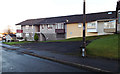
Bridgend Avenue
Houses at the Ardmore Road end of Bridgend Avenue.
Image: © Thomas Nugent
Taken: 13 Dec 2013
0.12 miles
4
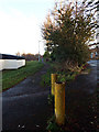
Site of the Princes Pier railway line
Between Boglestone Avenue and the industrial estate. Now National Cycle Network, Route 75.
Image: © Thomas Nugent
Taken: 13 Dec 2013
0.12 miles
5
Cycle path at Bridgend
National Cycle Network Route 75 runs on the course of the former Glasgow to Princes Pier railway line at this point. The building on the left is District No 19 Orange Lodge.
Image: © Thomas Nugent
Taken: 12 May 2016
0.12 miles
6
Cardross Road
Clydeview Road is to the right.
Image: © Thomas Nugent
Taken: 20 Feb 2012
0.12 miles
7
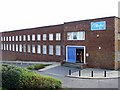
Playtex Factory
On Port Glasgow Industrial Estate.
Image: © Thomas Nugent
Taken: 5 Mar 2007
0.13 miles
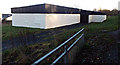
8
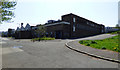
Former Playtex factory
On Gareloch Road in Port Glasgow Industrial Estate.
Image: © Thomas Nugent
Taken: 12 May 2016
0.13 miles
9
Bridgend Avenue
Viewed across Ardmore Road/Boglestone Avenue.
Image: © Thomas Nugent
Taken: 13 Dec 2013
0.13 miles
10
Social club
On Boglestone Avenue, near the industrial estate.
Image: © Thomas Nugent
Taken: 13 Dec 2013
0.13 miles