IMAGES TAKEN NEAR TO
LOCHWINNOCH, PA12 4DP
Introduction
This page details the photographs taken nearby to PA12 4DP by members of the Geograph project.
The Geograph project started in 2005 with the aim of publishing, organising and preserving representative images for every square kilometre of Great Britain, Ireland and the Isle of Man.

There are currently over 7.5m images from over14,400 individuals and you can help contribute to the project by visiting https://www.geograph.org.uk
Image Map
Images are licensed for reuse under creativecommons.org/licenses/by-sa/2.0
Notes
- Clicking on the map will re-center to the selected point.
- The higher the marker number, the further away the image location is from the centre of the postcode.
Image Listing (25 Images Found)
Images are licensed for reuse under creativecommons.org/licenses/by-sa/2.0
Image
Details
Distance
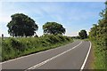
1
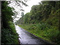
A Driech Day
Sustrans National Cycle Route No. 7, at this point following the line of the Old Glasgow and South Western Railway.
Image: © Chris Court
Taken: 21 Aug 2005
0.10 miles
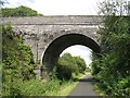
2
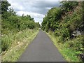
Lochwinnoch Loop Line cycle path
A fine stone arched bridge near Jeffreystock Farm.
Image: © Thomas Nugent
Taken: 13 Apr 2020
0.13 miles
3
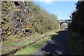
Cutting, Kilbarchan Loop Railway
Also known as the Dalry and North Johnstone Line, or Lochwinnoch Loop, this railway which is mostly in cuttings, is now a cycle path (NCN 7).
Image: © Richard Webb
Taken: 13 Aug 2009
0.13 miles
4
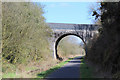
Bridge over the Lochwinnoch Loop Line cycle path
A fine stone arch near Jeffreystock Farm.
Image: © Thomas Nugent
Taken: 13 Apr 2020
0.14 miles
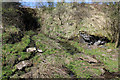
5
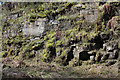
Bedrock by the Lochwinnoch Loop Line cycle path
Near Jeffreystock Farm.
Image: © Thomas Nugent
Taken: 13 Apr 2020
0.14 miles
6
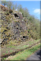
Bedrock by the Lochwinnoch Loop Line cycle path
Near Jeffreystock Farm.
Image: © Thomas Nugent
Taken: 13 Apr 2020
0.14 miles
7
Dalry and North Johnstone Line
Bridge over a disused railway built in an era when the current line between Paisley and Ayrshire could not cope with the volume of freight needing shifting. This relief line on the west side of the lochs was closed to passengers in 1966 and freight shortly afterwards. I have a 1:50 000 map with a small length still marked - northwards to Kilbirnie. Now it is a very popular cycle path - part of National Cycle Route 7 which takes a circuitous route between Carlisle and Glasgow via Galloway. The railway looping around the opposite side of the lochs from the original line is also known as the Kilbarchan Loop, or Lochwinnoch Loop.
The bridge carries a minor road over one of the many cuttings. The bridge uses concrete, the railway being built around 1905.
Image: © Richard Webb
Taken: 13 Aug 2009
0.15 miles
9
Stream by the Lochwinnoch Loop Line cycle path
Trickling down the side of a cutting on the west side of the line.
Image: © Thomas Nugent
Taken: 13 Apr 2020
0.15 miles
10

Bench by the Lochwinnoch Loop Line cycle path
A sturdy wooden bench by the side of the path.
Image: © Thomas Nugent
Taken: 13 Apr 2020
0.15 miles