IMAGES TAKEN NEAR TO
Forbes Place, PAISLEY, PA1 1UT
Introduction
This page details the photographs taken nearby to Forbes Place, PA1 1UT by members of the Geograph project.
The Geograph project started in 2005 with the aim of publishing, organising and preserving representative images for every square kilometre of Great Britain, Ireland and the Isle of Man.

There are currently over 7.5m images from over14,400 individuals and you can help contribute to the project by visiting https://www.geograph.org.uk
Image Map
Images are licensed for reuse under creativecommons.org/licenses/by-sa/2.0
Notes
- Clicking on the map will re-center to the selected point.
- The higher the marker number, the further away the image location is from the centre of the postcode.
Image Listing (1473 Images Found)
Images are licensed for reuse under creativecommons.org/licenses/by-sa/2.0
Image
Details
Distance
1
Forbes Place
Looking from Causeyside Street towards White Cart Water.
Image: © Thomas Nugent
Taken: 10 Sep 2011
0.01 miles
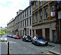
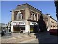
2
Forbes Place
Looking towards St Mirren Street.
Image: © Thomas Nugent
Taken: 18 May 2013
0.01 miles
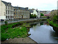
3
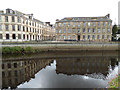
Forbes Place Beside the River Cart and Paisley Town Hall
Forbes Place is right beside the River Cart and across from the Paisley Town Hall in the heart of the town.
Image: © david cameron photographer
Taken: 10 Aug 2012
0.01 miles
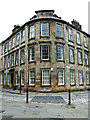
4
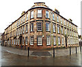
Forbes Place
The elegantly curved corner of the building at the south east of Forbes Place, overlooking White Cart Water, with views of the abbey. A Category B Listed building http://data.historic-scotland.gov.uk/pls/htmldb/f?p=2200:15:0::::BUILDING:38974 .
Image: © Thomas Nugent
Taken: 27 Jan 2014
0.01 miles
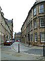
5
Forbes Place
St Mirren Street is on the left.
Image: © Thomas Nugent
Taken: 5 Jun 2016
0.02 miles
6
Forbes Place
Viewed across White Cart Water from Abbey Bridge.
Image: © Thomas Nugent
Taken: 25 Apr 2011
0.02 miles
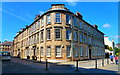
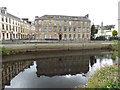
7
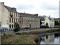
Forbes Place
An attractive B Listed building dating from around 1830, overlooking White Cart Water.
Image: © Thomas Nugent
Taken: 18 May 2013
0.02 miles
8
Forbes Place
Viewed across White Cart Water. The building on the right is Category C Listed http://portal.historicenvironment.scot/designation/LB38974 , the one on the left is Category B Listed http://portal.historicenvironment.scot/designation/LB38977 .
Image: © Thomas Nugent
Taken: 7 Aug 2017
0.02 miles
9
Forbes Place
Viewed across White Cart Water. The building on the right is Category C Listed http://portal.historicenvironment.scot/designation/LB38974 , the one on the left is Category B Listed http://portal.historicenvironment.scot/designation/LB38977 .
Image: © Thomas Nugent
Taken: 7 Aug 2017
0.02 miles
10
Forbes Place
By White Cart Water, viewed from Abbey Bridge.
Image: © Thomas Nugent
Taken: 7 Aug 2017
0.02 miles